“Time & Tide waits for no man!”
That was what the haulout manager reminded me when we had broken down on the way to to be hauled out. (big drama, diesel bug in the fuel tanks, and we had to throw out the anchor to avoid being blown on to the rocks) we were stuck, and the tide was going out and we needed high tide to be able to get the boat on to the cradle.
The tide here in Christchurch dictates when many clubs can sail as they are located on estuaries and can only sail a couple of hours either side of high tide. Our club is spared that hassle and we are an all tide venue, however Corsair Bay where Wildwood lives is quite shallow, and I have hit the mooring block before on very low tides.
The tide can be a real pain. I also once collected lots of wood on the beach to make a big pile for a bonfire later on that night. Sadly the tide came in and as I was sitting on the back of my boat I saw my pre-made bonfire floating past.
It also creates crazy currents when sailing through narrow channels, these currents are responsible for many of the grey hairs that I am now sporting on the top of my head…!
So what causes the tide to rise & fall and why do certain places have a larger range than others?
Well the sun and the moon are the main culprits. Their gravitational pull on earth basically causes the water to bulge out towards the celestial bodies.
So there is effectively a lunar and a solar tide cycle. The moon is of course closer to us than the sun, so the lunar tide is dominant. During it’s orbit, the moon’s distance to the earth changes as does it’s angle. This all has an effect on the height of each tide.
So when doing a tidal prediction, the experts combine both the lunar tide with the solar tide, to come up with a result. When both the lunar and solar are high at the same time, they effectively combine together to make a higher range – this is a spring tide – higher highs and lower lows. Then if the lunar high co-incides with the solar low tide, they effectively cancel each other out to make a neap tide – or a smaller high and smaller low – or less range.
So effectively the tide as we know it is the result of a combination of various separate tidal bulges caused by a particular set of Earth-Moon-Sun circumstances.
Here in NZ we have two high tides, and two low tides roughly every 25 hours or so.
BUT…. how come some places in the world have weird tides I hear you ask?
An area has a diurnal tidal cycle if it experiences just one high and one low tide every lunar day. Many areas in the Gulf of Mexico experience these types of tides.
A semidiurnal tide cycle occurs in areas that experience two high and two low tides of approximately equal size every lunar day. Many areas on the eastern coast of North America experience these tidal cycles. (and New Zealand!)
Mixed Semidiurnal tide cycle. An area has a mixed semidiurnal tidal cycle if it experiences two high and two low tides of different size every lunar day. Many areas on the western coast of North America experience these tidal cycles.
This is all caused by the continents, varying water depths, and the rotation & inertia of the earth as it spins around. The movement of the tides are effectively constrained within the individual ocean basins, so you can think of the tide as a wave that is trapped within each basin. If you take a container of water and move it from side to side, the level at each end will rise and fall, but the bit in the middle will stay the same. That describes how the water acts in semi enclosed waters – like the Med or the Persian Gulf. If you now move the container around in a circular motion, this shows how the tide acts in the oceans. The wave in the Southern hemisphere moves in a clockwise direction. The point in the centre again is an area where there is no tide.
The depth of the water also makes a difference. Just like waves coming in to a beach, when they hit shallow water, they slow down and rise up, causing the tide to be much higher than you might expect.
Some places have a range exceeding 10 metres, where as elsewhere – like the Mediterranean, Baltic and Caribbean there is almost no tide at all. We have about 2 metres here in Christchurch and up to 3.5 metres in other parts of the country.
So what else can effect the tide?
Tsunami’s & Earthquakes!
Stuff that you don’t expect to happen every day, but of course we have had to live with lots of earthquakes around here over the last four years. Thankfully they have all been on land, and therefore haven’t had much effect on the water. However back in early 2010 there was a big earthquake in Chile that caused a Tsunami in New Zealand! Thankfully it wasn’t too big, but it did play havoc with the tides here for a few days.
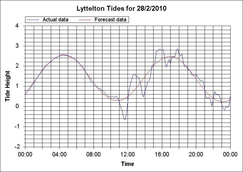
The red line is the prediction and the blue line is the actual.
Here is a picture of what Corsair Bay looked like just before mid-day at that very low point.


Crazy people were out walking on the beach. I sat up high in the car park watching. Other people took their boats out of the marina and out to sea. Thankfully nothing too terrible happened. But after what happened in Samoa and the Thailand tsunamis I think it is something to take very seriously!
Very low barometric pressure or prolonged periods of strong winds can also cause variations between the predicted heights and the actual results. The predictions are based on 1013 hPa, and a difference of 1 hPa can cause a difference of 1cm. There is seldom more than a 30cm difference.
Storm surges can also occur. You can get higher high tides if there is a strong on shore wind and a much lower tide if there is high pressure and an offshore wind, creating unusually shallow water.
Tidal streams are the periodic movement of water in a horizontal direction caused by the tide, whereas the normal tide is a vertical movement of water going up or down. The streams are usually caused in narrow channels, like Tory Channel, Cook Strait and French Pass and they can go up to 7kts. A rising tide causes a flood stream and falling is ebb. Also tidal streams are noted in the direction in which the tide is going – which is the opposite from the wind which is named in the direction it is coming from! So a Southerly wind comes from the South but a Southerly current is heading from North to South….
Arrraaagh my brain hurts!
Are you still with me readers??
Here are some other interesting things about tides that you need to know if you want to get your Ocean Yachtmaster certificate!
Standard Ports – are those for which we get a nice daily tide table prediction, giving the heights and times of each tide. These times are given in NZ Standard time, so you need to apply daylight savings differences. The heights are given in metres and are a measurement over Chart Datum – which is the depths as marked on the chart.
Secondary Ports – are those for which you don’t get an actual time, but you get given a time difference to apply to a port with a similar pattern.
Mean Sea Level (MSL) – is when the sea level is being really horrible. No really it is the average level of the sea over a long period of time and it is how deep the water would be if there were no tides at all.
Mean High Water Springs & Neaps – the average level of the sea at either Spring or Neap tides.
Highest and Lowest Astronomical Tides (HAT & LAT) the highest and lowest tide levels recorded.
Chart Datum – a water level so low that the tide (usually) wouldn’t fall below it. This is the depth as noted on the chart.
Ok so I am sailing in to a ‘Secondary Port’ how do I find out what the tide is doing?
Well! Thanks for asking that question! I just happen to be reading a text book telling me exactly how to do that!
First you take this handy little table below:
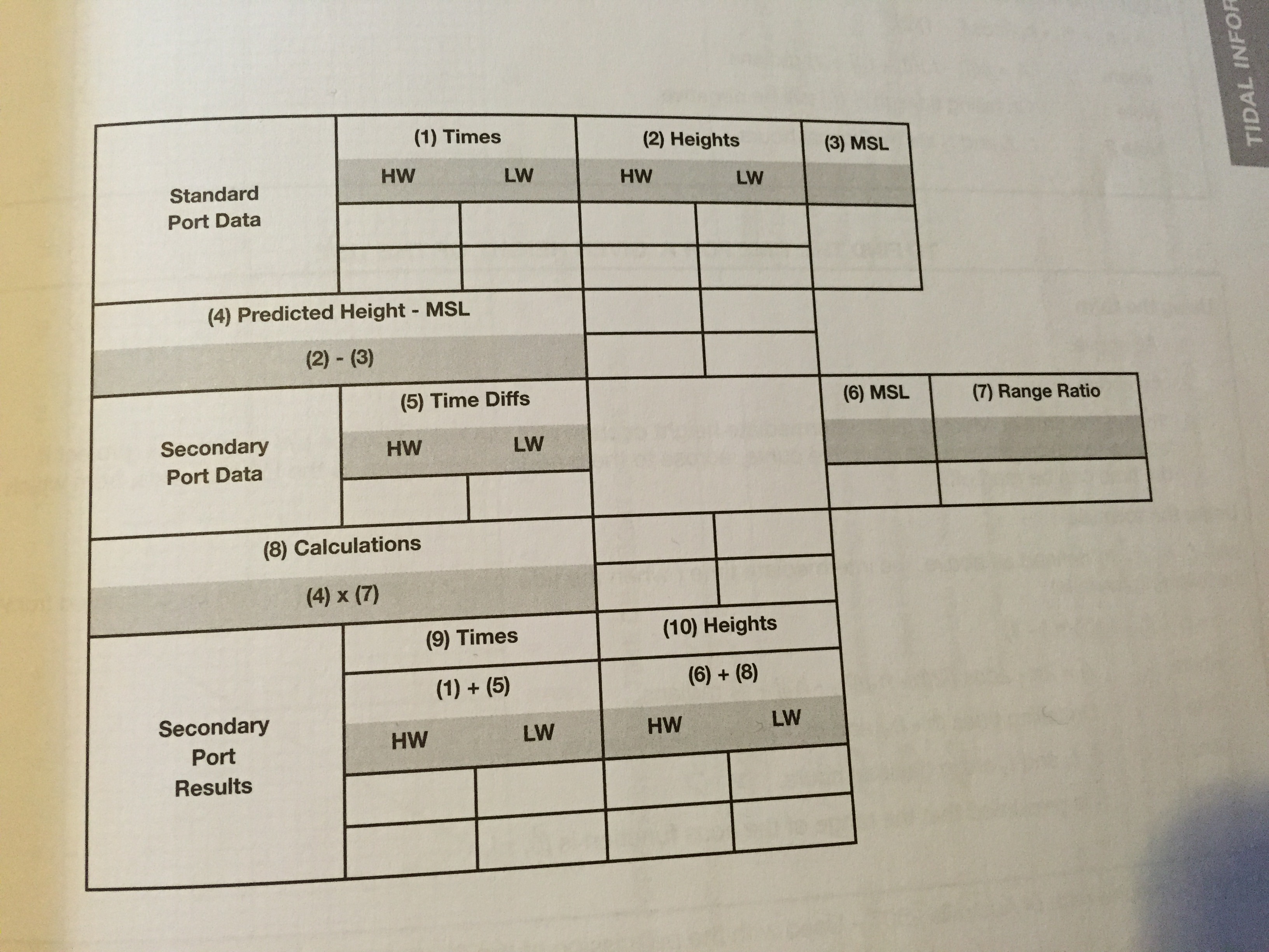
Then you get the standard port times and heights of high and low water and enter them in to boxes 1 & 2
Write in the MSL figure from the Standard Port Table in to box 3
Subtract the MSL value in box 3 from the predictions in box 2 and enter the results in to box 4 (the HW column should have the positive values and the LW column should have the negative values)
Get the Secondary Port date from the Secondary Port Tables and enter the time differences in box 5, and the Secondary Port MSL in to box 6 and the range ratio in box 7.
Multiply the figures in box 4 by the range ratio in box 7, enter the corresponding products in box 8.
(OK this is where I lose the plot…) Algebraically add the time differences for the Secondary Port in box 5 to the predicted times for the Standard Port in box 1 and enter the results in box 9. These are the times of high and low water for the secondary port.
Then add the values in box 8 to the MSL value for the secondary port in box 6 and enter the results in box 10. These are the heights of high and low water for the secondary port.
Ok I think I will need to practice this. My eyes tend to glaze over as soon as the words algebra and calculation enter the sentence… I have just tried it and it isn’t too bad, but of course the whole 60 minute thing makes it a bit more complicated than just simply subtracting one number from the other… anyway I think I have got the general gist.
So the next thing we need to learn about tides is how to fine the time or height between high and low water. Say for example you need a certain height of water to get out over a sand bar, or to get under a bridge etc. Well there is a handy table for that as well!
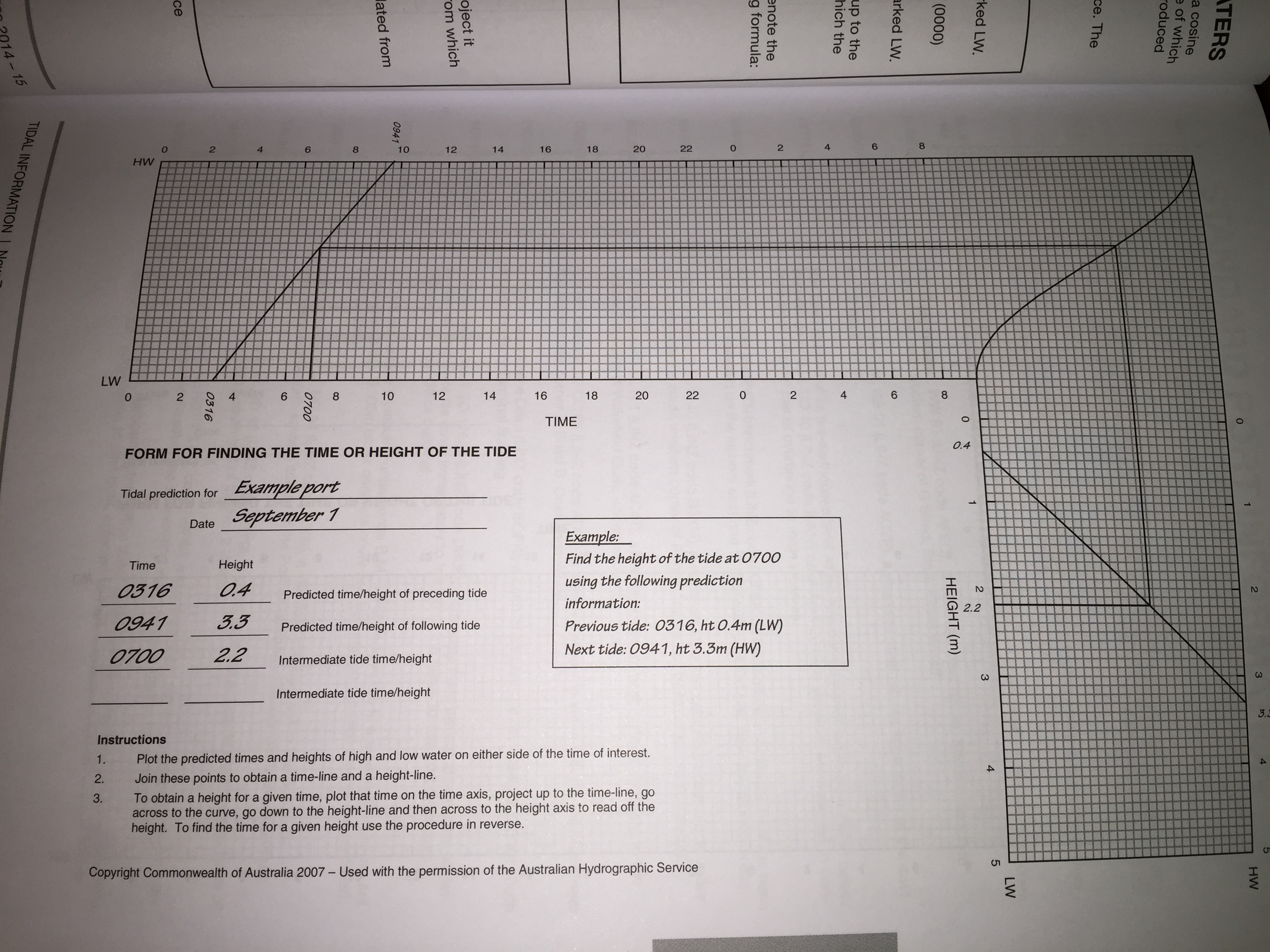
On the top column, you put a mark where the preceding tide and the following tide times are HW & LW respectively. Then you draw a line connecting the two
On the right hand side column you mark the height of the LW and HW of the preceding and following tide on the chart and then join those two lines together.
So say you wanted to find out how much water there was likely to be at say 7am, you draw a line up from 7am to where they intersect, then go along to the swirly line in the corner and down again to where the line intersects again, then go down from there and voila there is the height! You can of course do this in reverse to find out what time the tide will be at a certain height.
Another way of working all that out if you don’t have a handy chart is the rule of 12ths.
If a tide table gave us the information that tomorrow’s low water would be at noon and that the water level at this time would be two metres above chart datum and further, that at the following high tide the water level would be 14 metres. We could work out the height of water at 3:00 p.m. as follows:
- The total increase in water level between low and high tide would be: 14 – 2 = 12 metres.
- In the first hour the water level would rise by 1 twelfth of the total (12 m) or: 1 m
- In the second hour the water level would rise by another 2 twelfths of the total (12 m) or: 2 m
- In the third hour the water level would rise by another 3 twelfths of the total (12 m) or: 3 m
- This gives us the increase in the water level by 3:00 p.m. as 6 metres.
This represents only the increase – the total depth of the water (relative to chart datum) will include the 2 m depth at low tide: 6 m + 2 m = 8 metres.
Obviously the calculation can be simplified by adding twelfths together and reducing the fraction beforehand i.e.
Rise of tide in three hours 
Caveats
The rule is a rough approximation only and should be applied with great caution when used for navigational purposes. Officially produced tide tables should be used in preference whenever possible.
The rule assumes that all tides behave in a regular manner, this is not true of some geographical locations, the Solent where there are “double” high waters or Weymouth Bay where there is a double low water.
The rule assumes that the period between high and low tides is six hours but this is an underestimate and can vary anyway.
Other things to note:
Tide heights can differ appreciably from those predicted. This can be caused by:
- Wind – a strong wind blowing on shore over a period of time will increase the height of the tide, same applies when blowing offshore, particularly in bays and inlets.
- Weather – the sea level rises as the barometer falls and vice versa. Aprox 1cm for each millibar difference from average air pressure.
- Storm surge.
Explanation of Terms Used
- Tide – Periodic rise and fall of the sea
- Tidal Stream – Horizontal movement of water caused by the tide
- Tidal Range – Height of rise or fall of the tide
- Tidal Period – Time taken for the tide to rise of fall
- Chart Datum – Point from which all charted depths are measured
- LAT – Lowest Astronomical Tide
- MLWS – Mean Low Water Springs
- MLWN – Mean Low Water Neaps
- MHWN – Mean High Water Neaps
- MHWS – Mean High Water Springs
- HAT – Highest Astronomical Tide
- ASL – Average Sea Level
- Charted Depth – Depth below chart datum
- HW – High Water
- LW – Low Water
- Drying Height – height land dries above Chart Datum
- Standard Port – Location for which detailed tidal information is available
- Secondary Port – Location for which tidal information must be calculated from a standard port.
So there you have it! No excuses now for running aground eh!? Any other handy tide tips that you know of to add here?


Another really interesting post, Viki! We live by the tides and currents in the PNW. But when you spend so much of your time feeling connected to the tides, it’s always shocking when you meet others who have no real reason to be: David was sitting on the deck of Cambria one day when we were tied up to a dock and a young couple that was walking past stopped for a chat. For some reason, the subjected turned to the tides and the lady asked, “How often they change from high to low – once a year?”. Fortunately, David’s brilliant when it comes to these situations and he explained that, no, we experience a mixed semidiurnal tidal cycle and what that meant . . . as if he was asked the question every day.
LikeLiked by 2 people
Wow cool! As I really only have any experience of two highs and two lows per day and they are usually pretty close to being the same height! It must take a bit more getting used to having different heights and patterns. I hear you have some pretty strong tidal streams up there too. I think I saw a clip on Youtube of a boat trying to go through when it was in full swing somewhere up there?
Funny too to think that some people don’t even think about tides at all, when it is such a big part of a sailor’s way of life. Ahh fun times 🙂
LikeLiked by 1 person
I used to love this subject! Great stuff!
LikeLiked by 1 person
Well I am glad we don’t have to work through all the paper calculators for our coming and goings!Thank god for chart plotters with tidal movements! 🙂
LikeLike
Oh yes I forgot to mention that in the post! Love the Navionics App, it has got all that lovely info on there too!
LikeLike
I used to hate working out secondary ports. I now have a computer program that gives me the heights of times anywhere in the world for the next 100 years. Sometimes I just love computers.
Did you know when you sail through the Gibraltar straits into the Med you actually sail downhill by nearly a meter? The incoming water cannot keep up with the evaporation. Of course that means when we leave we have to sail uphill.
Concise, clear post on a complicated subject. Thanks Viki.
LikeLike
Wow! I did not know that!
LikeLike
Hi Viki. I think Mark is trying to be funny and pulling your leg, just to see what he can get away with. All tides run up and down, so using terms like sailing “uphill” and “downhill” is a way to amuse and confuse. Sailing with rather than against any tidal current just takes common nautical sense. Watch out for shallow water and take ol’ salts with ‘a grain of salt’. 🙂 By the way, your detailed reports are terrific, and bring back memories of the lessons we learned while scratching our keels.
LikeLike
Great advice! 😉
LikeLiked by 1 person
Pingback: New Caledonia Cruising Tips | Astrolabe Sailing
Pingback: Basic Navigation | Astrolabe Sailing
Pingback: Coastal Skipper | Astrolabe Sailing
Pingback: Celestial Navigation – The Moon | Astrolabe Sailing
Pingback: Niue for Cruisers | Astrolabe Sailing
Pingback: RYA Offshore Yachtmaster | Astrolabe Sailing