Thanks again for reading along on my Celestial Navigation notes as I study for the Ocean Yachtmaster Exam.
Hopefully you have already read the post about your Sextant. I have just also added a quick quiz at the bottom of that post, so if you want to skip back and read that first to check your learnings, you can do so by clicking here.
Ok lets look at the time and why this is so important to working out our position.
History
Way back in the 1675, King Charles II built an observatory in Greenwich, England. The purpose of the observatory was ‘to apply with the most exact care and diligence to the rectifying of the tables of the motions of the heavens, and the places of the fixed stars, so as to find out the so much desired longitude of places for the perfecting of the art of navigation’
In 1851 Greenwich was adopted as the location for the Prime Meridian – The basis of Longitude, and this was used in combination with lines of Latitude to create a grid over the globe for mapping and time keeping by Nations around the world. All points on the globe are measured from here in degrees either East or West of Greenwich and North or South of the equator.
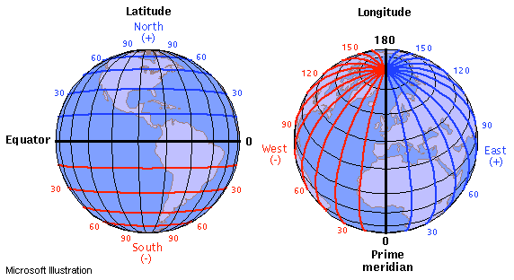
OK – so before we move on, if you are a bit rusty on Meridians of Longitude and Lines of Latitude you can read more about them in this blog post about some basic navigation terminology.
Time
Greenwich Mean Time or GMT was created to observe the average solar time at the location of the Prime Meridian. So basically the annual average time that the sun crossed directly over the Prime Meridian at noon. (Which can be anything from up to 16.4 minutes before or after 12.00 noon depending on the time of the year).
Equation of Time is the difference in time between 12.00 noon and the actual time that the sun’s ground position moves across the prime meridian. If you know what the equation of time for any given day is, then you can use that figure to determine when to take a noon sight (more on that later) or to work out the GHA of the sun at any time.
Originally the astronomers decided that the GMT day started at noon – the time that the sun went over the Meridian, while for everyone else our new day starts at midnight. This was of course a bit confusing. So the name was changed to Coordinated Universal Time or UTC and the day starts at midnight.
UTC is not actually a time zone – it is a time standard that remains constant. There is no daylight savings applied throughout the year.
For the purposes of navigation – GMT, UTC and UT1 all mean the same thing.
Time is measured in days, hours, minutes and seconds.
Time also co-incides with the passage of the sun. The Ground Position of the sun moves westward at the following rate:
- 360º in each day
- 15º every hour
- 1º every four minutes (of time)
- 15 minutes (of arc) each minute (of time)
- 1 minute (of arc every 4 seconds (of time)
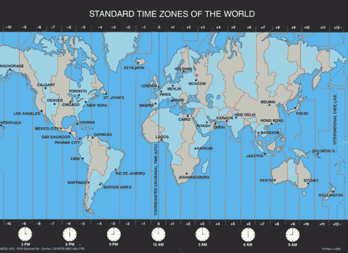
The world is divided up in to 24 different time zones – as per the picture above. Each zone is measured by 15º of Latitude (24 timezones x 15º = 360º). They begin 7.5 degrees either side of Greenwich. For every 15º you travel East or West of Greenwich you gain or lose an hour of time in relation to the time at Greenwich.
Greenwich is Zone 0 – Zones East of Greenwich are numbered -1, -2 etc, and the zones to the West of Greenwich are +1, +2 etc. The twelfth zone is divided in to two parts by the International Date line. The West is – 12 and the east is + 12. The zone number indicated the number of hours by which Zone Time must be increased or decreased to obtain UT.
Each region adopts the nearest geographical zone time – ZT as their standard time. But some areas adjust these times by parts of an hour to get their standard time closer to Local Mean Time – LMT. Many also have seasonal variations for daylight saving and to take in different geographical features.
Most boats maintain their Ships Time on the local zone time, changing as they move zones. The zone they use is based on their appropriate longitude – as opposed to the local time.
You can work out the zone time by using the map table above. You can use the mnemonic: If you are in Longitude West then UTC is Best – Longitude East – UTC is Least. Here in New Zealand we are in Zone 12 Longitude East so UTC is Least (or a lower figure) so we are +12 hours ahead of UTC.
If you are in America then you are in the Western Longitudes – Longitude West = UTC Best – so UTC is better (or greater than) UTC – so Zone 8 for example is -8 hours behind UTC.
The International Date line runs almost down the 180th Meridian, but does some dog-legs to ensure that islands belonging to a particular country stay in the same zone.
When you cross the International Date line on an Easterly Course, you take on yesterdays date. When you cross the line on a Westerly course you take on tomorrows date.
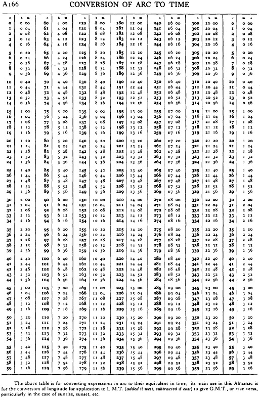
There is a table you can use for converting arc to time below. Click on the link for the pdf version. This will come in handy later on.
Calculating Time
Having an extremely accurate method of telling the time was a huge problem for historical navigators. Mr John Harrison spent over 43 years working on a chronometer – or extremely accurate timepiece which was successfully used by Captain Cook on his voyage to New Zealand in 1769.
These days a digital watch can usually be extremely accurate. You can check your watch accuracy by doing a regular time check. In New Zealand we have ‘pips’ on the hour on National Radio. There is also a continuous time check broadcast on 2.5, 5, 10, 15 & 20 MHz. Your GPS also should also have a Universal Time reading.
Some people prefer to have a stop-watch set at Universal Time. This can then be ‘stopped’ at the exact time that you take the sight with the Sextant.
So what has time got to do with Celestial Navigation?
Ok – imagine that the Earth is stationary, and the sun is revolving around the earth – moving directly overhead each of those time zones over a 24 hour period. This means that at the equator, the sun is travelling directly overhead at 15º an hour – or aprox 900kts.
Therefore to determine our location in relation to the sun (or another celestial body). When we measure our angle or distance from that body, we need to be very accurate with our time, as because they are moving so fast over our heads, just 1 minute of error of time in our calculations can mean an error in our location of around 15 NM.
Recording the Time when you take a sight
When you take a sight with your sextant you will want to also record the exact UTC date and time that you take it. Using a digital stopwatch as mentioned above can be a good idea, and make sure you have got the date right as well. The international date line runs through the middle of the Pacific, so make sure you are recording the correct date.
Your sextant readings and time notes should look something like this:
GMT – Sunday 22 August 2003
- 20h 52m 57s 41º23′
- 20h 56m 06s 41º55′
We will look at this more detail in the next post. In the mean time. Check the quiz below to see what you have learned.

Quiz
- What does GMT stand for?
- What does UTC stand for?
- How would you check an accurate UTC at sea?
- How many time-zones are there?
- What is the distance between time zones in degrees?
- What is LMT?
- What is ZT?
- What is the mnemonic for working out whether you are ahead or behind UTC?
All the answers can be found in the post above.
In the next post we will look the relationship between the Earth and the Celestial Sphere.
If you want to go back and re-read the post about Sextant’s you can do so here.


Pingback: Celestial Navigation – The Sextant | Astrolabe Sailing
had planned to go for the German equivalent of the Yachtmaster Offshore. Won’t do it and simply read your posts instead… 😉
LikeLiked by 1 person
Pressure is on now I know you are following along too! Hope I can explain it all ok. Let me know your feedback! 🙂
LikeLike
I do read every single one of your posts and have made some notes for my “skipper folder” already… however, as you are going into such (wonderful and great) detail, I do struggle occasionally re my English vocabulary. That’s not bad at all, just an additional task or challenge.
Btw: if you are ever going to give Yachtmaster classes and training, I might combine that with a NZ-holiday 😉
LikeLike
Lol thanks Hubert! I too am struggling and I speak English!
Would be great to see you in NZ. Summer is on the way! 🙂
LikeLike
Pingback: Celestial Navigation – The Celestial Sphere | Astrolabe Sailing
Pingback: Celestial Navigation – Sextant Angle Corrections | Astrolabe Sailing
Pingback: Celestial Navigation – Where is the Sun? | Astrolabe Sailing
Pingback: Navigation – Position Lines | Astrolabe Sailing
Hi Viki.. Just wanted to chime in with my solution to an affordable “chronometer”.. I bought 5 cheap Casio F-91W watches & set them all to UTC, & then observed them every few days for about a month & noted which kept time the best. I ended up with one that only looses about a second each week.. So as long as I re-set it at the beginning of a passage, I know to just add 1 second each week I’m navigating at sea. The rest of the watches are used for watch-keeping alarms 🙂
LikeLike
What a great idea! Thanks I am going to do that too! 🙂
LikeLike
Pingback: Celestial Navigation – Putting it all Together | Astrolabe Sailing
Pingback: Celestial Navigation – Equipment Required | Astrolabe Sailing
Pingback: Ocean Yachtmaster | Astrolabe Sailing
Can you link to your next post as mentioned as I can’t find it please? Great article thanks
LikeLike
Thanks so much! Glad you enjoyed and good spotting I will add the link in now, but for you it is https://astrolabesailing.com/2016/10/05/celestial-navigation-the-celestial-sphere/ Good luck!
LikeLiked by 1 person
Pingback: London | Astrolabe Sailing
Where’s the answer of the quiz?
LikeLike
Hi Andrew, all the answers to the quiz were mentioned in the text above. It was a more a way of you trying to work out if you’d absorbed everything without having to go back and look. Good luck!
LikeLike