Yes I am back to studying again! Time to refresh the old buoyage knowledge. It is handy stuff to know (especially if you have an exam coming up or are planning on navigating in a new area!)
Non sailors – please read on, you might learn something for a quiz night. Sailors will probably (hopefully) already know this, but you would be surprised at how many people launch their boats at the yacht club and then sail right over the top of the reef nearby which is clearly marked with a lighthouse and a cardinal mark. The reef actually extends quite a lot further south from where the Eastern cardinal marker is, so more than a few people have inadvertently hit it, even when they have been fully aware of its existence.
Cardinal Marks
These are marking an isolated area of danger, and they indicate what side you should pass. So if you see a South marker, then you should pass to the South of it. Of course you do need to know where South is – so have a look at the compass or the chart if you are unsure.
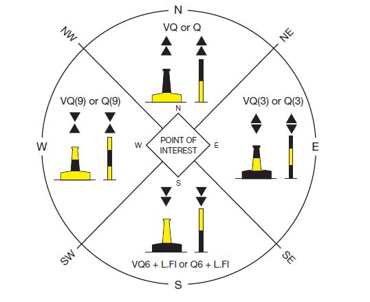
There are a few easy ways of remembering which is which – and the lights on top.
First of all the lights are always white and they are either Q = Quick or VQ = Very Quick flashing.
- North – the arrows on the top point up (i.e. to the North) and they are a continuous Q or VQ flashing
- East – one arrow points up and one points down. I remember this one as it kind of looks like an Egg – Egg = East and the light flashes in groups of 3 – just like 3 o’clock on the face of a clock.
- South – the arrows both point down (i.e. to the South) and they flash 6 times – just like the clock, and they add 1 long flash at the end of the 6. (Not sure why? I would have just been happy with 6 flashes)
- West – one arrow points up and the other down and I remember this one as it looks like a wine glass! Wine = West! And yes you guessed it, this one flashes 9 times! (Brilliant!)
Lateral Marks
Lateral marks identify the channel going in to the harbour – or in the direction of the flood tide. Just to confuse everyone, there are two systems IALA region A and region B. New Zealand, UK, Europe are system A and North & South America and some parts of South-East Asia use region B.
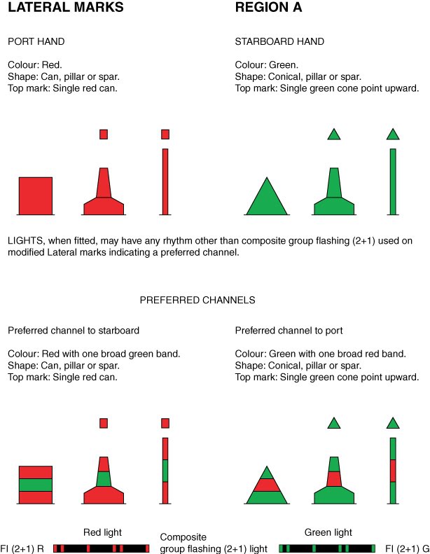
In region A the red cans mark the port side of the channel, and the green cones mark the starboard side of the channel (when going IN to the harbour)
I remember the shapes because of course port is red, and the shape is a can, which beer comes in – beer & port are both alcohol. Keep them on the left when you are coming in to a harbour.
Green = starboard, and the shape is like a cone, cones kind of look like a Christmas tree shape. Christmas trees are of course green, and green is starboard and so keep that one on the right hand side when you are coming in to harbour.
(Ok you may have a better way of remembering this than I do – but perhaps now you are starting to understand the way that my mind works…!?)
Their lights will either be red or green as above, and can have any kind of flashing sequence. Check your chart as it will tell you.
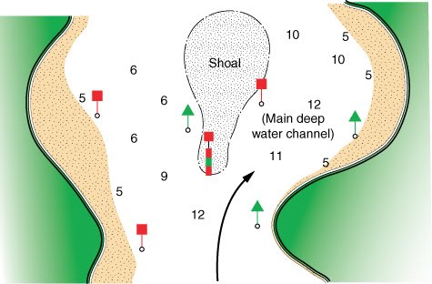
When there are two channels, these are indicated by the same marks, but with a stripe identifying which way is best. So in the picture below, the port marker at the bottom of the shoal is still marking the port side of the channel but it has a green stripe – saying “Starboard channel is best!”
These are identified at night with a composite flash – which is two flashes and then a gap and then one flash.
IALA B differs in that the shape of the marks is the same as A but the colours are different! Arraagh! I haven’t worked out how I am going to remember that…?!
Other Marks
There are also isolated danger marks, special marks and safe water marks to keep an eye out for.

Isolated danger marks are red and black with two black balls at the top. They flash white in groups of two. They indicate a relatively small danger in a patch of clear water all around. You can pass either side of these. I remember these as two black balls look like two black eyes – and no one likes to get a black eye, let alone two of them, so stay away!
Safe water marks are red and white vertical stripes and have a red ball on the top. Traditionally they are a good waypoint to aim for and mark the transition from open water to the harbour. They also have a white flashing light, with the sequences mentioned above in the picture. I remember these ones as the red and white stripes look kind of like a fun carnival or candy cane – kind of inviting & fun, possibly safe…? (Hmm anyway, as I said you can use your own way of remembering!)
Special marks are yellow and we have got one at the end of Lyttelton Harbour and it marks something – actually I am not sure what it marks, but it can’t be bad as we use it as a race mark. In fact I have even just looked it up on Navionics, and it doesn’t tell me there either what it is for. Anyway what it does say is that it has a yellow flashing light and a period of 5 seconds – so I presume that goes: flash! – followed by a pause of 5 seconds – flash!
So anyway they are special – the X reminds me of a pirate map – X marks the spot, and there is usually treasure underneath, and treasure is pretty special it also usually has gold which is kind of yellow, so yellow X = special mark.
There are also lighthouses and leading lights and their various different flashes and colours, but I am going to talk about those in another post.
Of course don’t assume that all dangerous rocks and channels are going to be marked. The ones that are marked are mainly for the benefit of big ships, so when you head off in to a small bay its unlikely that there will be any marks at all.
When we were in the Marlborough Sounds the other day, two cardinal marks indicating the ends of dangerous reefs were missing as they had been damaged in a storm. They did mention this in the local weather forecast, but you still need to keep a good eye on the chart in case they aren’t there.
Anything I have missed or do you have any other creative ways of remembering marks & lights? I would love to know!


Great summary! I don’t think special marks necessarily mark anything. I think that are there for yacht racing so they don’t need to use navigation marks – that was the story I heard anyway! Really enjoying your blog…
LikeLiked by 1 person
Thanks Blair! 🙂
LikeLike
I always learn so much about sailing from your posts. Thanks! My sailing buddy taught me the “Red Right Returning” phrase when coming into harbor here in North America and the Caribbean. Maybe that will help. Fair winds and safe travels!
LikeLiked by 1 person
Thanks Diane! And that is a great rhyme! I will remember that!:)
LikeLike
Great post – I remember west by ‘waist’ – I like yours better! 🙂 (not your waist, your memory aid! lol!)
LikeLike
Pingback: Ocean Yachtmaster | Astrolabe Sailing
Pingback: Coastal Skipper | Astrolabe Sailing
Pingback: RYA Offshore Yachtmaster | Astrolabe Sailing