I consider myself extremely lucky to live in one of the most beautiful countries in the world. In the South Island alone there is just so much to explore and discover, even for someone who has lived here for most of my life.
I am also extremely lucky to have an amazing group of friends who are always keen to come along on shared adventures, discovering the hidden gems of our homeland.
The Humpridge Track is one of those places that take a bit of extra effort to get to, but one you are there, you realise you are experiencing something very special.
In my world, long weekends come with compulsory adventure activities. It always amazes me how many people let these precious mini-break’s simply slip past without doing something special. Anyway Labour weekend – late October, was one such long weekend simply begging for an adventure. An advertisement for the Humpridge Track in a magazine caught my eye and the plan was formed.
Way down at the very bottom of the South Island of New Zealand is the small city of Invercargill. It’s claim to fame was that Mick Jagger once called it the ‘arsehole of the world’. But don’t let that put you off. It is the gateway to some incredible places including Stewart Island, The Catlins and Fiordland National Park. It also has a very cool shoe shop. A flight here from Christchurch takes about 1 hour, or otherwise it’s about an 8 hour drive.
We jumped on a plane after work on the Friday and then picked up a Thrifty Rental Car – minivan to drive an hour west to a small town called Tuatapere – gateway to the track.

We arrived at our accommodation at the Last Light Lodge about 9pm. They had very kindly kept the kitchen open to feed us hungry travellers, and we were pleased they did. The food was amazing, and with perhaps one too many glasses of wine we retired to our rooms.
Accommodation costs just $50.00 for a single and $70.00 for a double, in basic but clean rooms, complete with mini-kitchenettes. This is a great stop for budget conscious travellers, and to me looked to be the best place in Tuatapere to stop.
Breakfast was just as good as the dinner the night before and we left with full tummies eager for our adventure ahead.
Cedric greeted us a the Humpridge Track office and gave us the rundown on what we had to look forward to ahead. Lucky for us, the weather was absolutely perfect. The trees growing on a sharp angle gave us some clues as to how strong the winds can be in the heart of the roaring 40’s latitudes.
So at about 8.30am we set off on our 22km hike to Okaka Lodge.

The first part of the track went through the bush and then down some steep steps until we reached the beach.


Everyone started walking in their natural rhythm and we spread apart as we crossed along the golden sandy beach.
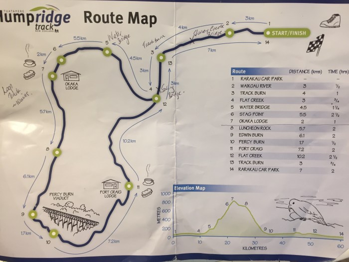
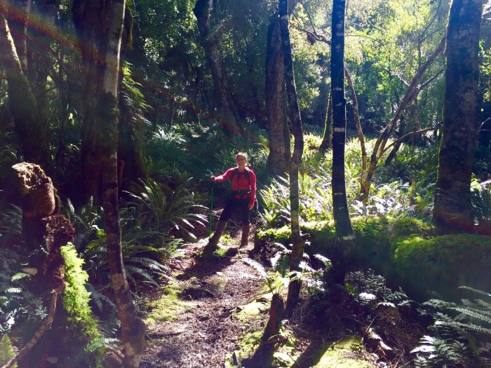
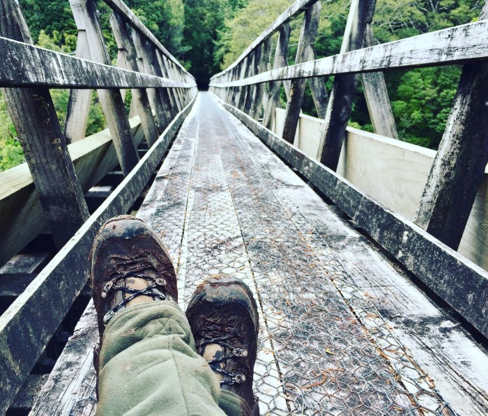
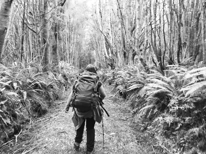
After 7km we turned off the beach and headed inland. Crossing narrow swing bridges and what felt like miles of board walks, weaving their way through the native bush and hovering over the soft forest floor.


We had lunch at the water bridge. There was a small shelter and seats there and a pot on a rope to fill with water from the stream far below. I had a 3 litre camelback in my pack and had already consumed much of that, so it was good to fill up and rest our weary legs.
Up until now, the track had been relatively easy. I had done lots of hill training and was feeling tired but good. Just another 8km to go to get to Okaka Hut high on the range above.
Onwards we trekked the first few km were fine. We had heard how tough this track can be and I was wondering what all the fuss was about. Until we got to the 4km mark when things started to get really steep. I was scrambling on my hands & knees at times to haul myself up. I was pleased my pack was relatively light.
After walking for what seemed like another hour, I was convinced that they must have missed putting in the 3km track marker. I was truely expecting to see a 2km sign, and carried on and on – but then in the distance – I saw it. 3km to go!! “Whaaaat?! – surely not” I almost cried. But time was marching on and I was determined to get to the hut. The visions of a cold beer almost became hallucinations as I continued scrambling higher and higher.
We got a text message from the others who had already arrived at the hut – “The last 3km are really hard” said Andrew. Then another one from Emma “The last two km are ok” Hmmm who to believe!?
But then the trees cleared and at Stag Point we had the most incredible view over a glassy calm Foveaux Strait and across to Stewart Island. Absolutely stunning.

We could clearly see Okaka Hut in the distance now. Not far to go, but when the damn 2km sign finally came in to view I wondered how it was that kilometres could possibly be so long!
Mark, one of the track guides from the hut had walked down the track to meet us and see what was taking us so long! He assured us that we didn’t have much further to go as he bounded down the track like a sprightly rabbit to round up the the other stragglers. Nice to know that someone will come out looking for you if you are overdue. Particularly if you were injured or something.
As we reached the ridge, the bush cleared completely leaving sub-alpine scrub of amazing colours and views out the other side of the Hump Ridge – absolutely spectacular.

When I began to wonder if I could walk another step I began hallucinating again. I saw Andrew standing in front of me holding two cold beers – it wasn’t until the cool brown liquid touched my lips that I realised he was in fact real – we had arrived! Beer has never tasted so good!
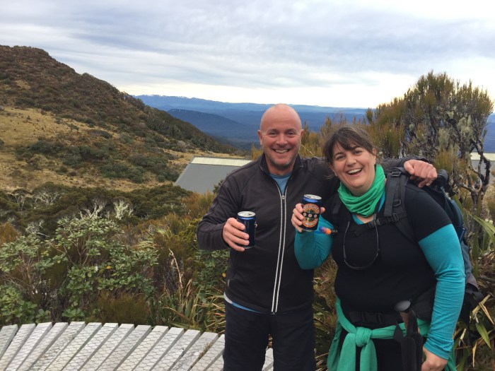
Needless to say Naomi and I were pretty pleased to have arrived. One of the many highlights of the Humpridge Track is that the huts stock wine and beer! As well as dehydrated food, all the cooking gear, a hot fire, bedrooms with sheets and big fluffy duvets AND… hot showers! I have been spoiled for luxury tramping forever more. Life was good. My feet were humming, but after a shower, a fantastic meal – Vic had made some vacuum packed curries and casseroles, and a few glasses of red wine in front of the fire – I was in heaven.
The next day we were up early. The hut manager makes a huge pot of porridge in the morning. Complete with cream and lashings of brown sugar. Delicious!
My feet were complaining about going back in to my boots. But we set off. Following the boardwalks back along the ridge and then down in to the spooky forest. It was another stunning clear and calm, slightly overcast day.


We stopped at Luncheon Rock for sandwiches before starting the steep descent down the mountain back to sea level.
It was at about this stage that my knees started to ache. I began using my hiking poles like crutches to ease the load on my poor joints. I started popping pain killers to take the edge off but it wasn’t pleasant.
At about 2.05pm we arrived at Edwin Burn bridge. These incredible wooden viaducts were built in the early 1900’s when the area was used for logging. We had only just missed James & Elisa who had left us a note written in stones at 2.00pm. Naomi and I stopped for a chocolate break and to rest our weary legs.
The next 10km were flat along the old railway line. The tracks themselves have long gone, but all the sleepers and the big iron nails that use to hold the tracks in place were still there. This wasn’t as easy to walk on as I had expected (hoped!). Parts of the track were quite muddy. But at least we weren’t going downhill.
The history of this area is fascinating. Story boards popped up along the way and I had read the book Viaducts Against The Sky by Warren Bird, before I came which gave me a good idea of the rise and demise of this extensive operation where at one stage over 200 people lived in this incredibly wild and remote place.
Naomi and I carried on, wandering through bush tunnels where the trees touched over head and then down in to a valley to pass beneath Percy Burn – which is one of the largest wooden viaducts in the world that is still standing – but sadly not strong enough at the moment for people to walk over. Here is hoping that they are able to raise funds to restore this incredible structure.
At one stage a fallen tree became an interesting obstacle for us to conquer. We went under and got very muddy in the process – apparently everyone else went over and around. Hmmm.


We made a brief stop at the Percy Burn DOC hut to write our names in the hut book. And then continued on. Once again the white markers began counting down the ludicrously long kilometres to go until we got to the hut. Just as we arrived it started to drizzle and we were greeted by swarms of sandflies.
Port Craig Hut is just as luxurious as Okaka and once again we made good use of the hot showers, and beer/wine cupboard and we all snuggled around the fire sharing our stories of the day and resting our weary limbs.


Another family was also having trouble with injured knees, and they had called for a helicopter to come and pick them up the following day. There were two spare seats left. We had another 20km to cover the next day and with a plane to catch from Invercargill at 6pm, we would have to get a move on. I was hobbling along like an old lady, popping pain killers and Vic was keen to catch the helicopter too. We figured that the $250 per person spent on the helicopter would be cheaper than buying everyone new tickets home if we made them miss our flight. So we decided to take the scenic route out.
So after more hot porridge in the morning, we waved goodbye to our friends as they set off and we wandered around some of the remaining relics of the deserted historic town and seeing the dolphins playing in the water beneath us while we waited for the chopper to arrive.


My aching knees were very happy to hear the sound of the helicopter approaching. They dropped off a lady and her dog who were coming in to check the stoat traps. Then we jumped in and quickly covered the 20km back to the car in about 3 minutes flat.


We took the van and drove to Riverton where we found a fantastic cafe overlooking the ocean and we gobbled down some hot coffees, mousetraps and carrot cake. Then we headed back to the end of the track to await the weary trampers with more cold beers.

We found a nice restaurant and everyone enjoyed another great meal before we headed back to the airport to fly home. My blisters were so bad that I couldn’t put my other shoes on so I stayed in my tramping boots all the way home.
Another great adventure with my fabulous friends.
Humpridge Track Tips
- http://www.humpridgetrack.co.nz
- It is a three day, two night walk
- Fly in to Invercargill – bottom of the South Island and get a rental car from there for the 1.5 hour drive to the start of the track
- The basic cost is $175.00 for the track, cooking gas and gear, bunk accommodation and hot porridge in the morning. Pay an extra $200 per couple for hot showers, sheets and duvets and a private room (saves carrying your sleeping bag) Well worth the money.
- Take cash or credit cards to buy beer and wine in the huts. You can even buy chocolate and Back Country Cuisine if you don’t want to take your own food in.
- There is also a DOC hut at Port Craig and another hut at Percy Burn. No other huts at Okaka Lodge.
- No crowds – a maximum of 40 (I think) people on the track at once. You can walk for hours without seeing another soul.
- Do lots of hill training before you go.
- Walking poles reduce the load on your knees by over 30% and are highly recommended particularly for the downhill day.
- Take good wet weather gear – we were particularly lucky with the weather when we went.
- Each day is about 20km per day – a long way for short legs! 🙂
- Take lots of water – there are a couple of places to fill up along the way
- The track staff are fabulous and really look after you.
- Read the book Viaducts Against the Sky before you go.
Thanks to James Jackson and Andrew Herriott for some of the photos in the post above.


A great read, thanks Viki, hope to see you guys on the track again in the not too distant future!
LikeLiked by 1 person
fantastic trail and post! You are making it more and more difficult not coming to NZ!! 😉
LikeLiked by 1 person
Loved the post and pics, Viki! One of these days I WILL make it to the South Island. It looks beautiful. Thanks for sharing.
~Diane
LikeLiked by 1 person
Looks gorgeous. That’s one of those walks I always wanted to do when I was in NZ but never got around to 😦
LikeLiked by 1 person
Pingback: Stunning Southland | Astrolabe Sailing
Pingback: Destinations Index | Astrolabe Sailing
Pingback: The Banks Track | Astrolabe Sailing
Pingback: The Kaikoura Coast Track | Astrolabe Sailing