More angles today… sigh – I do wish I had paid more attention in 5th form maths. Sorry Mr Sanders…
Let’s learn about Azimuth angles. As at the stage of typing this first paragraph of the post I personally have no idea what they are. Time to learn!
Remember that the angle we measured with our sextant, along with the Sun Almanac will give us the information required to draw a position circle around the ground position of the sun, and we are somewhere on that circle. However that circle is likely to be really large, so we need to narrow it down a bit.
So we use an Assumed Position – something close to our Dead Reckoning Position, but rounded off in to whole numbers. We then take that Assumed Position and look up the Sight Reduction Tables (see below) to determine the bearing of the sun at that particular time.
We can then draw a preliminary Line of Position at 90º from this bearing.
Finally we can calculate how far off the Assumed Position we actually are – either towards or away from the sun’s ground position. We do this by comparing the altitude we measured with the sextant (ho) with the altitude of the sun at our Assumed Position from the Sight Reduction Tables.
The Azimuth Angle – also known as Z is the bearing of the sun’s ground position from our boat’s position.
The best picture I can find to explain it is this one below from the book Celestial Navigation by Dominique Prinet.
In the example below, you can see that the bearing between our Assumed Position AP, the North Pole and the Ground Position GP of the Sun is 100º.
This angle is measured from the nearest pole – so in this example – The north pole.
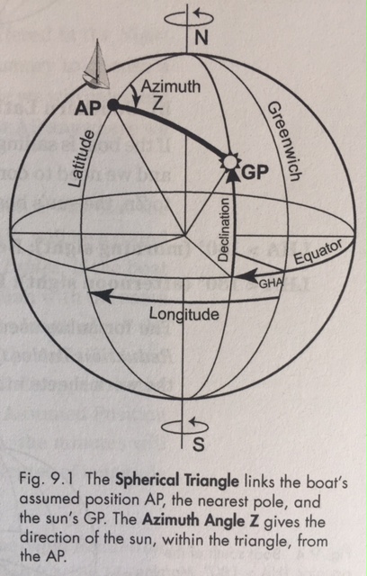
OK so this is where things start to get even more mathematical and smoke starts to come out of my ears. The Spherical Triangle or PZX Triangle is a measurement of the angles between the boat – in one corner, the pole in the second corner and the GP of the sun or star in the the third corner.
So you remember ages ago a post I did about Great Circles? Well spherical triangles are based on great circle lines – or lines that slice the earth in half – like meridians of Longitude.
I don’t know that I am explaining this particularly well – so it might be worth doing some googling of your own to make sure you understand the concept.
Sight Reduction Tables
Thankfully another very clever person has worked out all these angles in some more tables. These are called the Sight Reduction Tables and they can be downloaded for free here.
Each page represents a different Latitude. So go to the Sight Reduction table book and then turn to the page of your Assumed Latitude.
Remember we altered our Dead Reckoning Position to an Assumed Latitude and LHA – a nice round number, that is because only round numbers are offered in the Sight Reduction Tables. Click here to refresh yourself on how to work out your LHA or Click here to refresh yourself on Dead Reckoning Positions.
Then you need to decide if the sun’s Declination is the same as our boat’s Latitude – i.e. if our Latitude is 8ºS and the sun’s Declination is also South, then we will be looking at the tables for Declination being the SAME as our Latitude. Click here to refresh yourself on how to find the sun’s declination.
There is another table to use if the Declination is CONTRARY to our Latitude. i.e. if we are at 8ºS and the suns Declination is North, then use the other table.
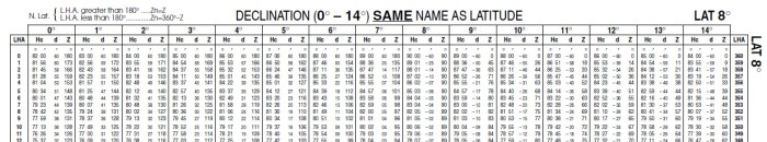
Along the top line is the Declination – along the sides of the table is the LHA 1-90º listed on the left hand side and then 360-291º on the other side.
So if the Declination was 4º we would go to that column, and then scroll down the column to get to the line corresponding with the appropriate LHA.
The numbers that we get from the table are the Hc – or theoretical altitude (which we compare with Ho – the corrected altitude from our sextant)
We are also looking for the Z number which is the Azimuth Angle.
Once we have got the Azimuth Angle of Z from the table – we can then work out what the Zn – or Azimuth Bearing is. Check out the bottom boxes in the sight reduction form below on how to work that out.
Z is the Angle between the sun and the nearest pole, whereas Zn is the bearing of the sun from the boat. The bit where it gets complicated is when then boat is in the opposite hemisphere to the sun, and whether it is morning or afternoon. Hence if you have a look at the calculations in the table below it changes depending on the LHA and Latitude N or S… (who on earth worked this all out!?)
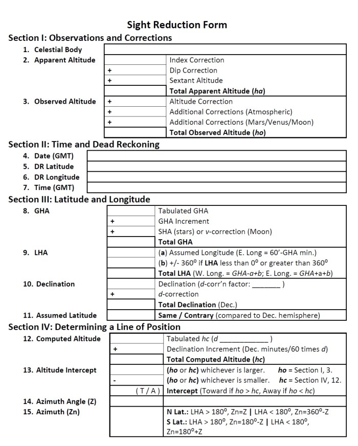
So finally we have reached the bottom of the Sight Reduction Form! That must mean we are nearly ready to actually put some lines on a chart! Tune in next time to find out how we do this.
Does your brain hurt? Mine does. However I do think it is sinking in.
If you aren’t understanding my blog posts. I highly recommend getting this book: Celestial Navigation by Dominique F Prinet. It seems to be the one that is making the most sense for me at this stage, and it has got lots of good examples to work through as well.


I can understand why you have smoke coming out of your ears! Thanks for writing all this up, Viki. Good on ya!
LikeLike
Pingback: Celestial Navigation – Plotting Your Position | Astrolabe Sailing
Pingback: Celestial Navigation – Putting it all Together | Astrolabe Sailing
Could I suggest, Celestial Navigation by Tom Cunliffe to be read in conjunction with information contained in this website as the path to enlightenment on this subject. Regards
LikeLiked by 1 person
Great suggestion! My notes aren’t the as good as Tom’s wisdom! 🙂
LikeLike