There are quite a few bits and bobs required for Celestial Navigation. So in today’s post we are going to take a look at what we need:
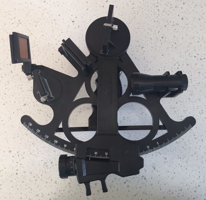
- A Sextant
I have got a plastic Davis sextant which is probably fine for what I want to use it for (i.e. studying for my exam, a bit of practicing when I am out at sea, and then maybe in an emergency if we lost our GPS) However plastic GPS are not as reliable as a metal sextant.
Rona, one of my blog readers recommends a brand called a Plath. They are more expensive but will give you a much higher degree of accuracy.
Click here to read about how to take a reading using your sextant.
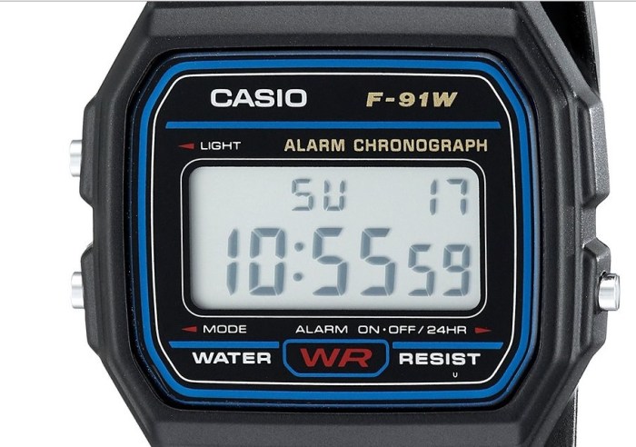
2. A Chronometer
A chronometer is essentially a very accurate watch. Click here to read why you need to know the UTC day and time (down to the second) for when you take your sextant sight. Thankfully these days digital watches are very accurate.
Blog reader Kerstin has a solution to an affordable “chronometer”.. She bought 5 cheap Casio F-91W watches & set them all to UTC, & then observed them every few days for about a month & noted which kept time the best. She ended up with one that only looses about a second each week.. So as long as she re-sets it at the beginning of a passage, she knows to just add 1 second each week she is navigating at sea. The rest of the watches are used for watch-keeping alarms.
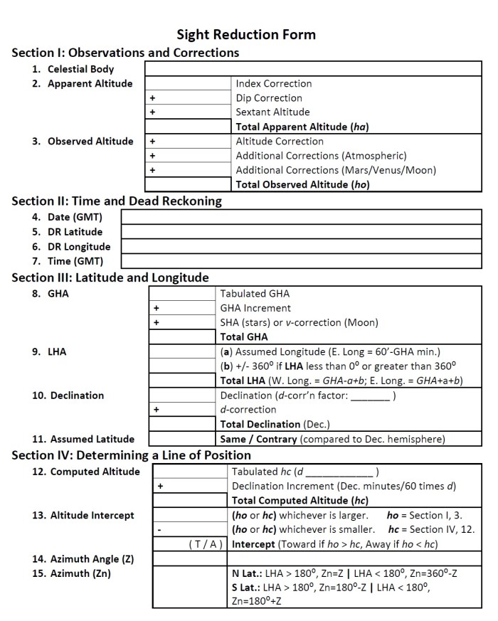
3. A Sight Reduction Worksheet
This is the form you use to plot all your numbers and ‘work out’ your position. There are lots of different versions on the internet. I have been using this one which you can download via this link. You can read about how to fill it in step by step in my other celestial navigation blog posts.
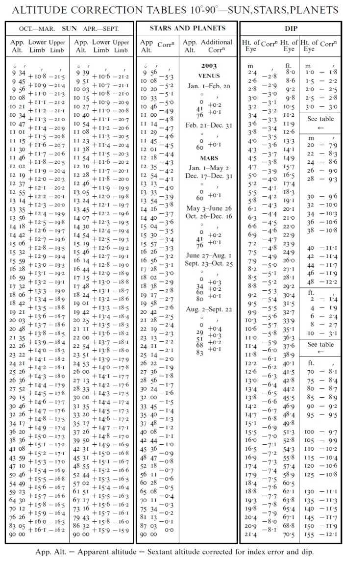
4. Tables
Some tables that you use for working things out do not change, so you can print out one sheet and be done. Others – like the sun, moon and stars almanac change from year to year.
The Altitude Correction Table below is used to make corrections to your sextant. This doesn’t change and can be printed and kept in your navigation workbook. Here is a blog post on how to use it.
The Sun Almanac.
This table tells you the ground position of the sun (and stars) at any given time of any day. It is published annually. You can either purchase the Nautical Almanac or there are a number of websites that publish the tables as well. Like this one.
Sight Reduction Tables
Once you have worked out exactly where the sun (or star’s) ground position is using the Almanac, you then use the Sight Reduction Tables to calculate what the altitude of the sun should be at your assumed position.
There are two kinds of Sight Reduction Tables.
The Sight Reduction Tables for Air Navigation (Pub 249) comes in three volumes covering from 30ºN to 30ºS and covers the sun, moon, planets and some main stars. You can download the volume that relates to the latitudes that you are sailing in. Free download here.
The Sight Reduction Tables for Marine Navigation (Pub 229) comes in six volumes, each of which contains two eight-degree zones of latitude. Download them here. They cover the entire celestial sphere, but are considerably bulkier than Pub 249 and are perceived as being more difficult to use than Pub 249.
However be warned, before you start printing either option, there are lots of pages. Choose the latitude in which you are going to be sailing and just download that part.
5. A Scientific Calculator
If you are better at maths than I am, and can figure out how to use your scientific calculator, you can actually use it to work this all out without the use of the tables! Quite how that is done, I am not sure, but if you wanted to go down this track and do some more research, then be sure to let me know how you get on…
6. A Plotting Sheet
This is the sheet that you are going to plot your course and sights on once you have worked it all out. We will be covering this in a future post. You can download it and read other useful tips on celestial navigation here.

7. Other Instruments
To assist with plotting you course, and for other chart work, you might like to get a parallel ruler.
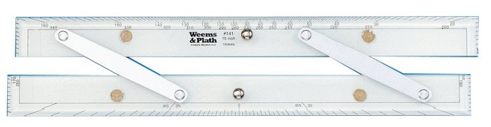
You will also need some dividers and a drawing compass to use for measuring distances and plotting position lines.
8. Books & Websites
There are lots of great resources to learn Celestial Navigation. I have been learning via the Coastguard Boating Education Ocean Yachtmaster course.
I also have this book: Celestial Navigation a Complete Home Study Course, which has been really good.
Kerstin recommends Hawaii by Sextant by David Burch & Stephen Miller. This book offers navigation details of a full ocean passage as an excellent way to learn the ropes of practical celestial navigation.
So bookmark those websites and print out the worksheets. Let me know if you have got any other great resources in the comments below.


Pingback: Celestial Navigation – Putting it all Together | Astrolabe Sailing
good post covering the basics, if you want to do it the easy way (without all the fun of calculating) you can just get one of those navigation calculators. They’re cheaper than a sextant too.
LikeLiked by 1 person
Oh I haven’t got one of those! Will check it out thanks 🙂
LikeLiked by 1 person
Mine is a Celestecomp, it’s old. I haven’t used it in years (or done much celestial navigation either). I sure wish I could find a way to get back out to sea!
LikeLike
Hi Viki; You’ll laugh, but after practise we did this with accurate wind-up watches in the atolls. Yikes, I know. One fun trick was to work out the calculations in advance for a specific time, and then read ‘distance off’ miles on the minute drum of the sextant. Resetting the mirror after a knock was stressful, but that’s just part of the joy of going to sea. Best to you, I’d give you an A. Happy sailing with that astrolabe.
LikeLike
Cool I didn’t realise you could do that. Thanks for the comment – and the A! I will let you know how I go in the exam. 🙂
LikeLike
Pingback: Celestial Navigation – Plotting Your Position | Astrolabe Sailing
Pingback: Gift Ideas for Sailors | Astrolabe Sailing
All of this information can be found at TheNauticalAlmanac.com
LikeLike
Thanks Craig I will check that out. 🙂
LikeLike