A couple of years ago, myself and a group of friends were on a tiny island called Pitt Island in the middle of the South Pacific Ocean. We got up really early, and climbed up the top of a mountain to watch the sunrise. With the island’s 11 residents still fast asleep in the village far below, and the fact that the international date line does a dog-leg around this particular island, we were pretty confident in saying that out of 7.5 billion people on earth, we were the first ones to see the sun that day.
Declination
As we already know, the sun doesn’t always rise in the same place all year round. It’s ground position moves from 23.5º North (above the Tropic of Cancer) to 23.5º South (above the Tropic of Capricorn) of the equator and this movement dictates the earth’s seasons.
The Equinox is when the sun is directly overhead at the Equator – this is on the 21st of March and 23rd September and this coincides with Spring and Autumn in the Northern and Southern Hemispheres.
The Solstice is on the 21st June and 22 December. This is when the Sun’s ground position is at its maximum distance from the equator – 23.5º North or South – above the Tropic of Cancer or the Tropic of Capricorn, this coincides with mid winter or mid summer in the Northern and Southern Hemispheres.
As the stars are so far away, their declination is constant throughout the year. The moon and planets vary. With the moon moving about 25º North and South every four weeks and the stars varying over a period of years.
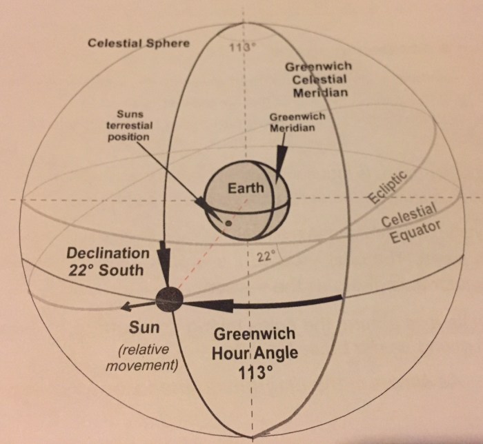
Cast you mind back to the post about the Celestial Sphere – or have a quick refresher by clicking here now. For the purposes of celestial navigation, it is easier to think about the earth being stationary and the sun and stars are revolving around us.

What we want to find out is the coordinates of the Sun’s GP – Geographic or Ground Position – i.e the point on the earth directly below the sun at that particular point in time.
Remember that declination is the celestial scale for Latitude (or degrees north or south of the equator) and GHA is the celestial equivalent for Longitude (or degrees WEST of the Greenwich meridian).
So at the Equinox (when the sun’s ground position is directly over the equator) the declination is 0º. At the Solstice the sun’s declination is 23.5º North or South.
GHA or Greenwich Hour Angle
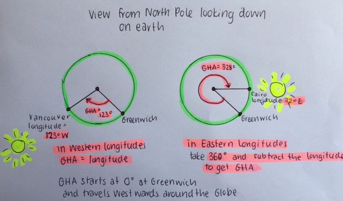
GHA or Greenwich Hour Angle, or the Sun’s longitude on the celestial sphere, is always measured Westward from the Greenwich Meridian. This number changes with the rotation of the earth at a rate of 15º every hour.
Thankfully some very clever person sat down and worked out the Sun’s (and moon, planets and stars) exact declination and GHA for every hour of Universal Time, every day of the year, and put it in to tables for you to use. (Wow – clever people…!)
When you look at the tables for the Sun you will see that at 1200 UTC every day, the sun is pretty close to crossing the Greenwich Meridian . It varies slightly from day to day because UTC is based on the the average (or mean) sun crossing the Greenwich Meridian, and what we are measuring is the passage of the True Sun.
These tables can be found in a Nautical Almanac and look like the picture below. If you haven’t got an almanac, then you can also download them from the internet. The Almanac changes from year to year. Here is a link to a brilliant celestial navigation website – Backbearing.com and they have got a sun almanac you can also use which looks a bit different to the picture below but the information is the same.
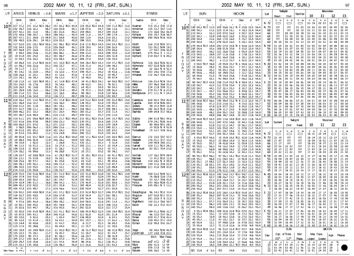
The Nautical Almanac has all the information for the declination and GHA of the sun, stars, planets and moon.
You can see in this picture that at the top of the page the year, month, and days (in UTC) that this page refers to. In this case 2002 May 10, 11, & 12.
On the left hand side of the page the days are split out by day and then hour.
It is pretty hard to read in that pic, but the Sun column (in the left hand column of the right hand page) will show the GHA of the sun increasing by 15º every hour. Next to the GHA is a column showing the declination.
At the very bottom of the page you can see that the d or declination is increasing by 0.6’per hour. You need this rate of change figure for the next part.
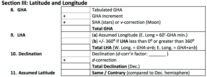
So to find the ground position of the sun for UTC on the 10th of May 2002 at 1000, you would open your almanac, turn to the page for the 10th of May, and then look down until you find 1000. There you will find your GHA and Declination for the hour. Add these figures in to the table below in to the boxes beside Tabulated GHA and Declination.
Then look at the bottom of the page to find d – or the rate of change of declination and make a note of that in the d-corr’n factor:_____ of the table below.
Remember to make sure that you are working on the correct date of UTC – this could be different to the date of the time zone you are in!
Increments and Corrections
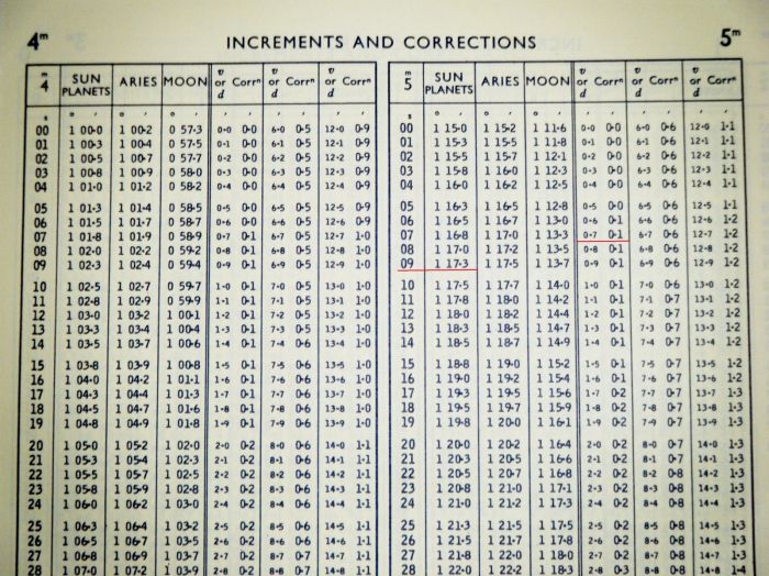
But of course it is unlikely that it will be exactly 1000 hours when you take your sight, so to find the increments for minutes and seconds you need to have a look at another table! This can also be found in the almanac.
There is a different table for every minute of the hour. You find the table of the minute you are looking for, and then look down the table for the seconds to find your increment.
So if the UTC time we took the sextant reading was 1005 and 9 seconds, you would turn to the 5 minute page, and scroll down to the 9 seconds line and then look across in to the Sun and planets column. The increment would be 1º 17.3′ – as per the underlined bit in the picture below.
We add the 1º 17.3′ to the GHA figure we got from the sun almanac table to get our total GHA.
Declination however changes very slowly, so we don’t need to worry about its change between seconds.
Have a look at the figure you wrote in the d-corr’n factor box on your table. This might be something like 0.7. Now look down the v or d corr’n column until you find 0.7 as underlined below, this is your declination correction. To determine whether you add or subtract this to the declination figure you already obtained, you need to decide whether the declination is increasing or decreasing.
Confused yet? Either get a hold of an almanac or print out the Sun tables from the link I provided above from the Backbearing website and have a good look at them. Seeing so many numbers on one page completely terrifies my non-mathematical mind. But if you break it down step by step it doesn’t seem too daunting.
Remember I am tackling this all in bite sized pieces. I promise that it will all eventually come together.
I am reading about 4 different books on the subject and picking the bits out from each chapter relating to the same thing until they make sense to me. There are also lots of great websites and wikipedia also helps if you aren’t quite getting the terminology.
Please comment below and let me know if you are still following and how you are getting on. 🙂
Quiz:
- What is the Equinox?
- What is the Solstice?
- How many degrees North and South of the equator does the Sun travel?
- What is declination
- What is GHA?
- How do you work out GHA for Western Longitudes?
- How do you work out GHA for Eastern Longitudes?
- What information does the almanac give us?
- What are increments and corrections?
- What period does each page of the almanac cover?
- What does Zenith mean?


Do you realise that what you see (the sun) was about 8 minutes ago???
LikeLike
Wow no I didn’t! Is that to do with the speed of light? Interesting!
LikeLike
Yes …and our closest star (alpha centori) 4 years ago … amaising really
LikeLike
Wow that is cool. Something else to think about when sailing at night! 🙂
LikeLike
I sure wish I had a chance to take such a training, start to finish! Some day I will, but first I need two good eyes. 😉
Still following along and learning a bit of it, so thanks for plugging along with it! I did bring my sextant aboard when we left Maine, just in case I met a mentor…
LikeLiked by 1 person
🙂 thanks for following
LikeLike
Added Pitt Island to the list of places I’d like to visit!
LikeLiked by 1 person
It is an awesome place!
LikeLike
I took a break for dry dock too 😉
Another book to recommend which helped me get into the rhythm of working out sites & plotting a DR & fixes: Hawaii by Sextant, by David Burch & Stephen Miller.. Really cool version of a workbook using actual log entries from a vessel sailing Victoria BC to Maui!!!
LikeLiked by 1 person
Cool thanks! I’ll check that out 🙂
LikeLike
Pingback: Celestial Navigation – Local Hour Angle | Astrolabe Sailing
Pingback: Celestial Navigation – Putting it all Together | Astrolabe Sailing
Pingback: Ocean Yachtmaster | Astrolabe Sailing
Pingback: Celestial Navigation – Azimuth & Sight Reduction Tables | Astrolabe Sailing
Many thanks for describing my website ‘backbearing.com’ as brilliant. Nice website you’ve got too. You’re living the dream!
Andy
LikeLiked by 1 person
Thanks for your comment. I have learnt lots from your site. Thanks heaps!
LikeLike
Excellent material! I agree with your explanation and diagram of the Sun’s position as viewed from the North Pole for GHA & LHA- it’s a lot easier to understand. However, it seems that all CN work (the ones designed to confuse you) use the South Pole as reference for illustrating GHA and LHA. Any idea why they do that?
Thanks,
Craig
LikeLiked by 1 person
Thanks Craig, it makes my brain hurt just even trying to think about why that might be… hmm I actually don’t know!
LikeLike
great site. I’m trying to take noon sight and got a 10nm error yesterday. Was using lower limb, and not correcting for height of eye, so I’m close! But, the next error seems obvious and important: earth oblateness. Doesn’t that bias my noon sight doiwn? What’s the correction for that?
LikeLiked by 1 person
Good question! I had to google that and I’m still not sure that I understand it or have any idea how you’d check for that lol! If you find out the answer please let me know. 🙂
LikeLike
Hello,
how can I download the Nutcal Al-manac book on the mobile? Thank you
LikeLiked by 1 person
Good question and I am not sure. Perhaps there might be an app or something you could use?
LikeLike