Tropical Revolving Storms are not something you want to encounter when you are in a yacht. Thankfully they typically form only in special conditions, or seasons, so sailors can attempt to avoid them by sailing away from the areas where they form over those particular months.
Cyclones in the South Pacific, Hurricanes in America and Typhoons in Asia – they are all the same thing, but with different names.
Recipe for a cyclone:
- Pre-heat the ocean to at least 26ºC
- Get an area of low pressure
- Add lots of warm moist unstable and disturbed air
- Mix well – using the Coriolis Force (between 5º-20ºNorth or South of the Equator)
Cyclones need the Coriolis Force to generate the spin. There is no spin created at the equator, so that is why cyclones don’t form there (or cross the equator).
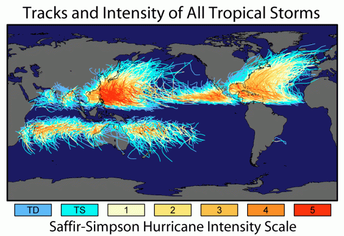
In the South Pacific, the cyclone season is over the Southern Hemisphere summer – November to April ish. With the greatest frequency in January – March.
In the Northeast Pacific the cyclone season is from June to November, but the Northwest Pacific has tropical cyclones all year round – with the most in early September and the least in February & March.
The North Atlantic has cyclones from June to November with the most occurring in August & September.
In the North Indian basin, their cyclone season is April to December – peaking in May and November.
Of course you should always be keeping an eye on the weather forecasts but some other signs that there may be a cyclone approaching include:
- a long low swell
- Extensive high cirrus clouds in the direction from where the storm is approaching
- A change of 3 hPa or more below the mean average pressure for the area
- A marked change in the direction of wind and speed
To find the direction of the storm – face the wind and the centre of the storm lies aprox 90º on your left hand side.
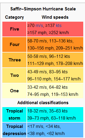
A hurricane force wind is defined as any wind averaging 64 knots. These storms are given different categories depending on the wind speed. (I don’t ever want to know what 137kts feels like – yikes!)
Once a Tropical Revolving Storm has been identified it is given a name. There are several different Tropical Cyclone warning centres located around the world and they keep their own list of names in alphabetical order. There are two warning centres in the South Pacific – one in Brisbane and one in Fiji, so sometimes the names might not appear in alphabetical order. The storms are named to make them easier to identify one storm from another in weather reports.
They need the warm water to keep going, so if they move over land or head down in to cooler waters, they dissipate and become tropical storms or depressions. They are described as ‘pressure valves’ allowing the heat from the ocean to be released and dispersed.
In the Southern Hemisphere, wind blows around the storm in a clockwise spiral flow inwards. Their general track is usually in a South Westerly direction but it may change and then head South East.
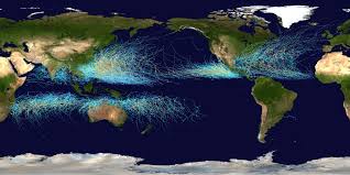
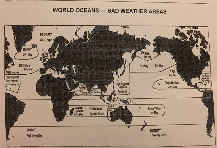
You can see that there are very rarely any cyclones forming in the South East Pacific or South Atlantic oceans. This is because of the cold currents that flow up from Antarctica – keeping this part of the ocean too cold for the cyclones to form.
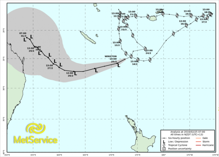
However if you check out the track of Cyclone Winston earlier this year – the storm seems to roam around all over the place… the line with the mini cyclones is its actual track and the grey area is where its forecast to end up.
The wind revolves around the eye of the cyclone. In the centre the winds can be quite light. However as the centre moves over the area the intense wind once again resumes but from a completely different direction.
So if you have the misfortune of ending up in an Ocean at the same time as a tropical cyclone – what should you do?
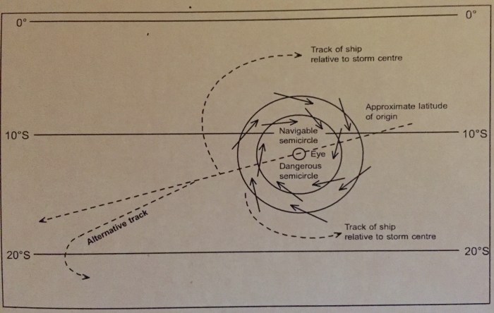 Southern Hemisphere Tropical Cyclones.
In the diagram above there is a navigable semi-circle and a dangerous semi-circle. The Navigable semi-circle means that you will have the wind behind you, so it will be easier to sail away from the most likely track of the storm.
However if you are on the Southern side of the storm, the wind is likely to be on the nose, making sailing away from it a lot harder. If you turn and go with the wind, then its possible it will run over the top of you!
The general rule of thumb is to make maximum speed with the wind on the port side – on the port bow if you are on the dangerous side or on the port quarter if you are on the navigable side. If you are in the path of the storm you should head for the navigable semicircle as fast as you can!
Of course the opposite applies in the Northern Hemisphere…
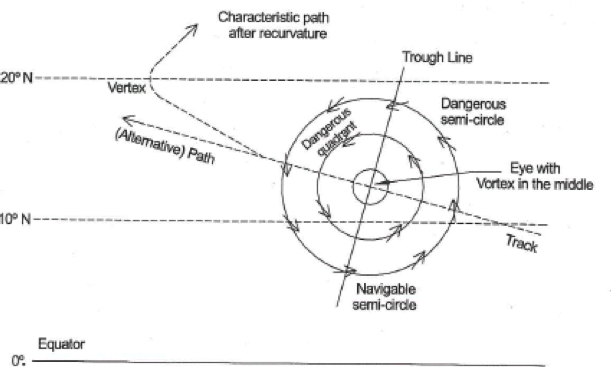
Northern Hemisphere Tropical Cyclones
Weather satellites are the main way of detecting and tracking tropical revolving storms. It is important to have a way of receiving weather forecasts when you are at sea.
The area of low pressure raises the sea level, combined with the intense wind speeds can cause huge waves and storm surge which can cause much devastation on land. Also with the wind direction changing as the storm moves over the same area, can create very steep seas. Category 4 storms have been known to create waves up to 90 feet high.
Weather Bombs
Any depression whose central pressure falls more than 14hPa in 24 hours at 30º latitude is called a weather bomb.
During the main South Pacific cruising season of May to October, most weather systems are anticipated a long way off as they travel around the mid-latitudes. The main problem is the lows that form and deepen in the sub tropics – 22-30º South. They can form very quickly (within 24 hours) and develop gale force winds around them. If they move further South they can deepen even further and cause a storm covering a large area and causing large seas. They can form faster than a weather map can reasonably show or predict.
These lows can occur at any time, but they are least likely in September-October and most likely May-June.
So we have talked a bit about avoiding Tropical Revolving Storms while at sea. If you are in port you might want to consider how you are going to ride out the storm. Click here for more ideas.
So here is what the Ocean Yachtmaster Course requires me to know about Tropical Revolving Storms:
- Tropical revolving storms locations, seasons and likely tracks √
- Areas where TRS activity is likely √
- Seasons when TRS activity is at a maximum √
- Appreciation of the difference between a TRS and a tropical depression √
- Know sources of TRS warnings √
- Understand the visual signs of TRS √
- Know the pressure changes associated with TRS √
- Awareness of the unpredictability of TRS behaviours √
- Awareness of sea temperatures associated with the formation and continuance of TRS √
- Knowledge of the sea state and wave heights likely at or near a TRS centre√
- Navigating near a TRS√
- Understand the importance of avoiding the centre of a TRS√
- Appreciate the dangers of TRS√
- Understand the difficulties of small vessels to make progress to windward in strong winds√
- Understand the dangerous quadrant√
- Understand the navigable quadrant and the safe semi-circle√
- Understand the requirements for preparing the vessel, stores, equipment and crew near a TRS√
- Know the importance of monitoring the progress of TRS√
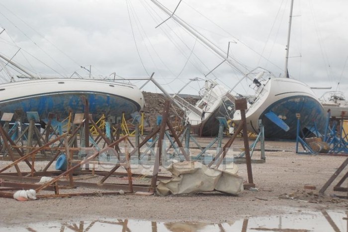
Here in the South Island of New Zealand we get our fair share of stormy weather, mostly from the South. However sometimes we get the tail end of a tropical revolving storm, even after it turns in to a tropical storm or depression, they can still continue wreaking havoc. Cyclone Pam which caused a lot of destruction in Vanuatu last year, carried on to the Chatham Islands (a lot further south), ruining a newly built breakwater and boat ramp on Pitt Island.
Have you got any experience with Tropical Revolving storms you can share?
Check out my other Meteorology posts here:


Pingback: Ocean Yachtmaster | Astrolabe Sailing
Excellent, what I like about your articals is that they have some great pictures to and text is easy to understand, not too much detail…So come on Viki, put this all together and get a Book out 🙂
LikeLiked by 1 person
Lol thanks Dudley! 🙂
LikeLike
Pingback: Meteorology – Weather Forecasts | Astrolabe Sailing
Pingback: Meteorology – What about the wind…? | Astrolabe Sailing