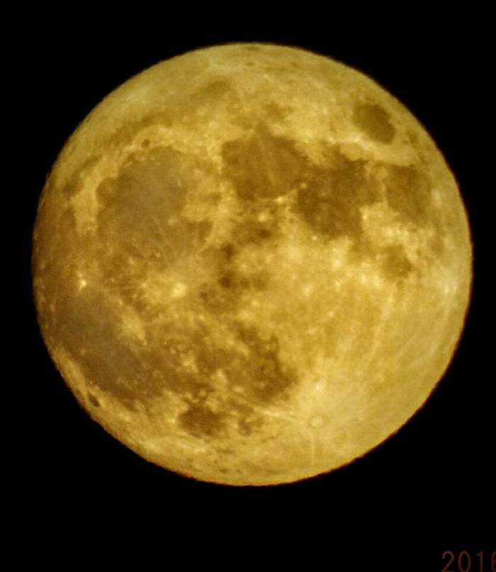
Apparently I am not the only person to have been given a big fright by the moon sneaking up over the horizon at random times of the night, and my crew continue to debate whether or not the moon landings were real or a huge conspiracy. Whatever your opinion and whether it has ever frightened you or not, the moon can be another handy tool to use when it comes to celestial navigation.
Did you know that the moon rotates on its axis in the same time that it takes to rotate around the earth. This means that we only ever see the same one side of the moon from earth.
The moon is also a major influence on the tides.
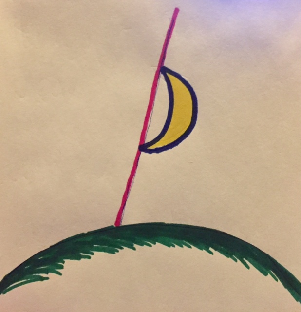
Using the Moon as a Compass
You can also use the moon in certain phases to show you North or South. If you draw an imaginary line between the sharp points on a crescent moon, and then continue the line down towards the horizon. If you are in the northern hemisphere, then this point on the horizon indicates South and if you are in the Southern hemisphere then it points to north.
This works best if the moon is high in the sky.
The moon (like the sun) rises in the East and sets in the West, so you can also use this as a guide for a basic compass direction.
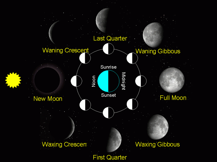
Phases of the Moon
The moon, just like the earth always has one side illuminated by the sun. It is just the moon’s position in relation to the earth that determines which side of it we see. Sometimes we see the shadowed side and the illuminated side at the same time, which is how we get to see the different shapes.
A new moon is the beginning of the cycle. This is when you can’t see the moon at all. This is when the moon is positioned roughly between the earth and the sun. The illuminated side of the moon is on the sun side of the earth, and this means we only see (or don’t see) the moon’s shadowed side.
From there it grows in to a crescent shape or less than half, and gradually grows in to a half moon, or first quarter, and then gibbous means larger than half, until eventually it becomes a full moon and then starts decreasing again. Waxing means when the moon’s size appears to be increasing, and waning is when it is decreasing.
When the moon is full, it is when it is positioned roughly in alignment with the sun and the earth on the opposite side of the earth, meaning we see its entire illuminated side. The moon’s orbit is about 5° off from the earth and sun orbit, so this is why the earth doesn’t block out the sunlight when the moon is full. When this does happen – then this is called a lunar eclipse.
The moon has an elliptical orbit around the earth, and so the distance between the earth and the moon varies throughout the year. It is on average about 382,000 km away from the earth.
When the moon is closest to earth it is called perigee. When it is furthest away it is called apogee.
When perigee occurs at the same time as a full moon – you get a super moon.
You can use various websites to find the phase of the moon like this one: https://www.moongiant.com/calendar/August/2018
From this website I realised that the side that is illuminated is actually opposite in different hemispheres.
There is a Scouting Trick that says that “if you can cup the full side of the moon with your right hand it’s waxing and left hand it’s waning” which is true in the Northern hemisphere – but its the opposite in the Southern Hemisphere.
There are some other ways of working it out too:
1) Ask yourself whether the Moon is leading the Sun across the sky (in which case it’s waning) or trailing the Sun across the sky (as it does when it’s waxing).
2) If the timing is convenient, ask this: Can you see the Moon at sunset? Then it’s waxing. Can you see the Moon at sunrise? Then it’s waning.
3) Learn the features on the Moon’s face. This is extremely reliable and will tell you the approximate age of the Moon even in photos or in circumstances when you have no other information.
… ” there’s Mare Crisium, that little well-defined oval on the upper right. You only see that when the Moon is waxing (and since these are features ON the Moon, it doesn’t matter at all what hemisphere you’re in, which way you’re facing, or if you’re standing on your head!!).”
Celestial Navigation with the Moon
The moon can be especially useful for the navigator as it can often be seen during the day, so you can take a sun sight and a moon sight almost simultaneously to obtain two position lines and get a fix on your position.
The moon orbits around the earth approximately every 29.5 days. It’s ground position on the earth is explained in the same way as the sun using Declination and GHA. The daily position of the moon can be found in the Nautical Almanac in the moon column (see below).
You can use the same Sight Reduction form that we have been using for the Sun sights:
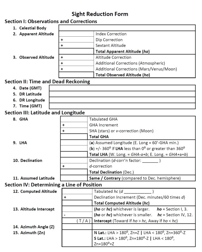
So you take your sextant reading in the same way as you would for the sun, using either the upper or lower limb of the moon.
You then make the necessary adjustments to the sextant reading – your Index error and Dip only to get your apparent altitude.
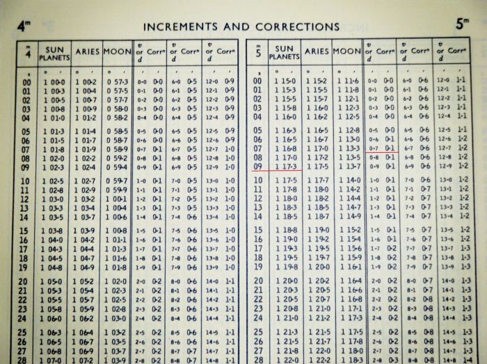
Then here is a slight change. Altitude Correction – you need to use the Moon altitude correction table instead of the sun one – which can also be found in the almanac. As with the sun you need to use a different figure depending on whether you used the Upper or Lower limb to take your sextant reading. To use the table you need the Apparent altitude and the HP figure from the almanac.
HP is Horizontal Parallax. The moon is much closer to earth and parallax takes in to account the difference between the centre of the earth and our position on the surface. HP varies with the moons orbit and is about 40 times greater than the parallax adjustment required for the sun.
You enter the table along the top apparent degrees and then down the side to find the minutes. This corresponds to your altitude correction figure – add that to the apparent angle.
Then you get the HP figure from the almanac and then using the same column you used in the step above, go to the bottom of this table and find the HP correction which is also added to get your Ho or total observed altitude.

The position of the moon can be found in the almanac in the same way as finding the sun.
The hourly rate of change of GHA is less than that of the sun, but the declination changes more rapidly, so the d value is usually larger and varies from hour to hour. There are two other columns involved when working out a moon sight which you can see in the picture above. These values are HP and v.
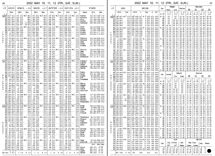
v is another moon correction which is always added to the increment for the GHA of the moon in the Increments and Corrections table in the almanac.
If you look at step 8 and 10 on the sight reduction worksheet above, you can see that you add the v correction to the GHA and the d correction to the Declination.
Then everything else works the same as the sun sight – working out your LHA and Azimuth etc.
You can read more about putting your sight together and then plotting your course on these blog posts.
Well I have certainly learned a few new things about the moon by researching this post. What have I missed? Have you ever been frightened by the moon rising in the middle of the night? Do you believe in the moon landings?


What a great post! Super informative. I had no real idea that the moon could be used for navigation. Incredible. Hopefully, one day I’ll be able to learn this technique and be good at it! 🙂
LikeLike
great post, thx, the moon just seen from earth as rotating around the earth in 29.5 days but i reckon it’s actually 27.3 days.
LikeLiked by 1 person
Correcting for parallax is much easier if you use the air almanac HO 249 available online for free. You don’t have to use that confusing HP table. Simply look up your altitude and it gives you a correction value. I learned with 229, but 249 is easier. Everything is rounded to whole integers. It skips the tiny decimal points. Perhaps slightly less accurate, but makes the math so much easier. If you want extreme precision, pull out one of your many gps devices on board.
LikeLiked by 1 person
Oh thank you! I will definitely check that out!
LikeLike