The Ocean Yachtmaster syllabus requires that you know a few things about compasses – how they work and how to use one.
The Earth’s Magnetic Field
Imagine that inside the earth is a powerful bar magnet. This lies with its blue end toward North and its red end towards South. It’s axis is not exactly aligned with the earth’s spin axis. The lines of magnetic force emerge from the red end and re-enter the blue end – these form a field of magnetic lines of force around the earth.
The two places on the earth directly over the axis of this magnet are the poles. The magnetic poles do not line up with the earth’s true poles.
Magnetic dip occurs where the lines of force leave the surface of the earth – so the closer you get to the poles, the weaker a magnetic compass becomes.
Magnetic meridians do not align with true meridians. The horizontal angle difference between the true meridian and the magnetic meridian is called ‘Variation’
Variation changes with locality on the planet and time. The compass rose on a chart states the variation in that locality. So you must always use this variation to convert your magnetic course to a true course on the chart. You can also find the information in an Almanac or cruising guides.
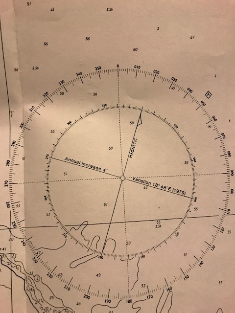
So you can see in the compass rose above that in 1979 the variation was 18º48’E. You can also see that it increases by 4′ each year.
So this is quite an old chart – so its possible that the variation amounts have changed, but anyway to work it out you figure out how many years between 1979 and 2018 – which is 39 years.
39 years x 4′ per year = 156′
Remember that there are 60′ in a º
So to work out how many degrees you divide 156 minutes by 60 so: 156/60 = 2.6º
You can convert .6 of a degree in to minutes taking the decimal portion of the number, i.e. just the digits to the right of the decimal point, and multiply it by 60 (minutes in an hour).
So .6 x 60 = 36′
So there is 2º36′ of extra variation to add to the variation figure of 1979 which was 18º48’E
Or 18º48′ + 2º36′ = 21º24’E
Of course its going to be pretty damn hard to steer a course that accurate, but its worth knowing how to work it out properly as your navigation teacher is going to want to see an accurate number – not just a hazardous guess!
If the variation is WEST – the North Magnetic Pole lies to the left of the True North Pole. If it is East it lies to the right of the true north pole.
“Variation East Magnetic Least – Variation West Magnetic Best”
Here are some examples to try:
- Your True course is 040ºT, the variation is 23ºE – what is the magnetic course?
- Your True course is 090ºT, the variation is 10ºW – what is the magnetic course?
- Your True bearing is 273ºT, the variation is 5ºW – what is the magnetic bearing?
- Your True bearing is 008ºT, the variation is 13ºE – what is the magnetic bearing?
- Your Magnetic bearing is 273ºM, the variation is 7ºW – what is the true bearing?
Answers –
- 017ºM
- 100ºM
- 278ºM
- 355ºM
- 266ºT
The Boat’s Magnetic Field
A boat has many magnetic objects on there which can interfere with the magnetic compass. This is caused by any iron or steel in the structure, any fixtures or fittings made from ferrous materials and also other electrical instruments near the compass. For example the keel, radio fittings, engine etc.
A vessel made of steel, ferro cement or iron can have magnetism induced in to them from being hammered or sitting in a position for a long period of time. Timber and fibreglass boats are not affected however the motor and other fittings can still be affected. These components on a boat can change magnetic properties over time.
The compass should be mounted as close to eye level as possible, where it is clearly visible from the helm and away from any magnetic (ferrous) material. The lubber line should be correctly aligned when mounted.
The errors that this causes to the compass is called ‘Deviation’
Deviation is the horizontal angle at the compass between the magnetic meridian and the direction of north indicated on the compass.
Deviation also changes depending on the heading of the vessel, any structural changes to the boat, the passing of time, mooring the boat near a strongly magnetized boat or structure, lightening, collision or grounding, welding etc.
Hard Iron – means that the components remain magnetised for the rest of the vessels life. Or permanent Magnetism
Soft Iron components do not retain magnetism – they adopt the earths magnetic field induced in to them while on a particular heading. It is called induced magnetism, and can gradually change each time the boat changes course.
Each boat has its own magnetic field – however this can be measured and noted on a Deviation Card. This needs to be checked on a regular basis as the magnetism can change as noted above.
To convert a compass reading to a true reading on a chart – apply the following –
Compass +- Deviation = Magnetic
Magnetic +- Variation = True
Or to remember – CDMVT – (Cadbury Dairy Milk Very Tasty)
Or TVMDC – (True Virgins Make Dull Company)
“Deviation West, Compass Best. Deviation East, Compass Least”
Here are some examples to try
- Your True course is 114ºT, variation is 4ºW, deviation is 5ºE, what is your compass course?
- Your True course is 302º, variation is 7ºW, deviation is 5ºW, what is your compass course?
- Your Compass course is 250ºC, deviation is 2ºW, variation is 3ºE, what is the true course?
Answers
- 113ºC (114 + 4 = 118M – 5 = 113)
- 314ºC (302 + 7 = 309M + 5 = 314)
- 251ºT (250 – 2 = 248 + 3 = 251)
Click here to download a handy table to help work variation and deviation out
How to make a Deviation Card
- Ensure the vessel is in normal seagoing condition – upright and with no magnetic objects near the compass.
- Check that the lubber line is in line with the boat’s fore and aft line.
- Select a distant landmark clearly visible but far enough away to prevent parallax errors.
- Slowly song the boat in the smallest circle possible.
- Take a bearing on the landmark on at least eight equidistant spaced headings, keeping the boat steady on each heading.
- Calculate the magnetic bearing and compare this to the compass bearing, the difference is deviation East or West.
- Plot the deviation on to a table to obtain a deviation curve
- From this table you can then calculate the deviations for the headings in between the eight bearings you took.
- East should match West deviations.
You can download a table for making a deviation card on the ultimate boating spreadsheet.

You can also use the sun and celestial navigation techniques to check the deviation of your compass.
Heres how to do it at sunrise
- Work out your latitude
- Make sure you’ve got a clear sky so you can see the sun
- Work out the suns declination in your almanac
- Apply your Latitude and the Declination to the table to give you the true bearing of the sun at sunrise and sunset
- Once you have your true bearing of the sun – apply variation – to give you the magnetic bearing of the sun
- Sight over the compass when the sun is just lifting above the horizon – note the bearing.
- Any difference is deviation
- Name it using the East is Least, West is Best rule
Local Anomolies
In certain areas are unusual magnetic disturbances. They can be caused by iron on the seabed, wrecks or power cables. Other disturbances can be caused by overhead power lines, bridges, steel ships etc.
Charts with permanent disturbances can have a note explaining the disturbance and give a figure by which the variation may differ. You must be very cautious in these areas especially if you are navigating by compass at night or if your autohelm is using a compass course. In these areas do not rely on your compass for a position fix.
Heeling Error
Heeling error is caused by objects above or below the compass and can change depending on the angle of the boat’s heel. It is like an imaginary vertical magnet within the vessel. If the vessel is heeled over then the centre of this magnetism effectively moves to one side of the compass card and can cause its own deviation. If the vessel is on a Northerly or Southerly course, then the movement of the vertical magnetic field will be at right angles to the compass card and can cause maximum deflection of the compass from North. However if you are on an Easterly or Westerly course then the movement will be parrallel with the magnets on the compass card – therefore causing no deflection – but the card may dip in the vertical plane.
Heeling error may be identified and corrected by a compass adjuster using a heeling error instrument. It is corrected by the appropriate placement of vertical corrector magnets below the compass
The Fluxgate Compass
This is a simple electromagnetic device that has two or more small coils of wire around a highly permeable magnetic material to directly sense the direction of the horizontal component of the earths magnetic field.
The advantages are that the reading is in electronic form and can be digitised and transmitted easily and displayed remotely and used by an autopilot. It can be sited in an ideal position – low down in the boat and away from any magnetic influences.
The fluxgate must be kept as flat as possible by mounting it on gimbals or using a fluid suspension system. All the same errors are inevitable when the vessel is being tossed around by rough seas.
Fluxgate compasses are also subject to deviation and variation and heeling error, however it may be possible to apply variation electronically and there may also be a facility to swing the vessel and apply deviation automatically.
Taking Compass Bearings
Whatever type of compass you use for taking a compass bearing – be it the steering compass, compass binoculars or a hand bearing compass, you must convert the compass bearing to a true bearing before plotting it on a chart – i.e. apply variation for the location you are in.
It is pretty difficult to take a bearing with a steering compass, so a hand bearing compass or compass binoculars are better, however because these two compasses are mobile, it is difficult to know their accuracy in regards to deviation. It is best to use these compasses in an area of the boat that is least likely to be affected by any deviation, and for practical purposes it is best to assume that there is no deviation (but just be aware that there probably IS some deviation present and so these bearings should be used with caution).


I can’t resist – we used True Virgins Make Dull Company – but we couldn’t ‘teach’ that one (not the done thing! lol! So we used, in class, TV Makes Dull Company…. I love the choccie one though, but now I want some! 🙂
LikeLike
Ha ha! Love it! Funny the things you remember. I had the chocolate one committed to memory from about 11 years ago when I did Coastal Skipper course! Hey if it helps to remember these things then I am all for it! Now I just need a system to remember how to do all the steps in the celestial navigation…!!
LikeLike
Because of the 23.5 deg variation EQC when assessing out house got the East/West wrong and the schedule now really confuses the hell out of builders!! Out home site on a NW angle so with variation not accounted for it looks Northerly!!! – only perhaps CHCH people will understand this reply, and for you non CHCH people CHCH is Christchurch and EQC are the guys who fix your house after our 2011 Earthquake!
check out http://www.gns.cri.nz/Home/Our-Science/Earth-Science/Earth-s-Magnetic-Field/Declination-around-New-Zealand/Declination-across-NZ-2010
LikeLike
Arraghh I bet it does! EQC are difficult enough to deal with, let alone having to try and explain the finer details of variation and deviation to them!
LikeLike
i wish i knew enough to comment!
LikeLike
😉
LikeLike
Pingback: Ocean Yachtmaster | Astrolabe Sailing
Pingback: Basic Navigation | Astrolabe Sailing
Pingback: Coastal Skipper | Astrolabe Sailing
Pingback: Navigation – Position Lines | Astrolabe Sailing
Pingback: The Ultimate Boating Spreadsheet | Astrolabe Sailing
Pingback: RYA Offshore Yachtmaster | Astrolabe Sailing
In your experience, what is the typical maximum an minimum deviation for an electronic compass? The reason I ask is that my new compass is +-5deg, which is no better than anything I’ve used in the last 25yrs.
LikeLiked by 1 person
Good question and I am not actually sure. Is there anything magnetic nearby that could be causing the error?
LikeLike
It’s a portable unit suitable for dinghies, and have tested it in the middle of a sports field and beach. Phone/tools/glasses 3m+ distant. The deviation curve is sinusoidal, which I think is normal, but the magnitude of the error surprises me. thanks
LikeLiked by 1 person
Hmm interesting! Sorry I don’t know the answer, but interested to know too if you do find someone who has some knowledge!
LikeLike