If you were excited by the prospect of measuring your distance off a landmark by vertical angle then today’s lesson in Coastal Navigation is going to completely knock your socks off!
Today faithful blog readers, we are going to learn all about using horizontal angles to find out where you are.
First of all you are going to need a couple of prominent landmarks on the chart and in view from where you are. In our example, lets use the headland entering in to Purau Bay in the bottom middle of this chart, and the little Island on the other side – Ripapa Island. 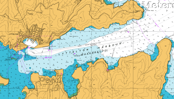
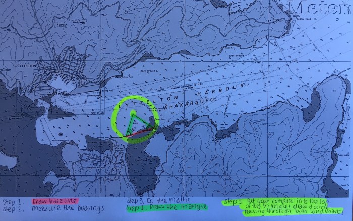
Step 1. Draw a line between the two landmarks.
Step 2. Measure the angle from the boat. Either by taking two simultaneous compass bearings, with your compass binoculars or a hand bearing compass – and then using the difference between the two bearings. Because you are just measuring the angle between the bearings, you do not need to take in to account variation and deviation.
Or you can measure the angle by turning your sextant horizontally and measuring the angle between the two points (and calculating for index error).
Step 3. If the angle you get is less than 90º then subtract the angle from 90º to get the construction angle.
If the angle is greater than 90º then you subtract 90º to get the construction angle.
Step 4. Use a protractor to plot the construction angle from the baseline – making sure you put them on the boat side of the base line. Lets say in our example the construction angle is 30º so we measure out 30º from each landmark along the baseline and then draw a triangle.
Step 5. Draw a position circle using your drawing compass. With the sharp end on the top of the triangle and the circle passing through both landmarks. Your boat is somewhere on this circle!
You now need to combine this position circle with some other Coastal Navigation technique of obtaining a position line to figure out just where exactly you are.
Personally, this seems like a lot of maths and drawings to get quite a rough idea of where you might be on a circle. But perhaps you might be able to combine this with being on the transit line of the leading lights, or by taking a bearing to the channel marker in the middle of the harbour.
Thank goodness for GPS! Still I guess it is really important to know how to do all this stuff in case you do end up needing it one day (and for my upcoming exam…) Lightening strike, battery/engine failure etc. Plenty of reasons why your GPS might not be working. What are your thoughts? Do you still practice these Coastal Navigation skills on a day to day basis?


Why not take a bearing or sight of the first mark then using the sextant, or talking a second bearing get the angle to the second land mark. Go to the chart, from the land mark rule a line for the first bearing/land mark. Then, from the first line using a protractor, parallel rule (from compass rose) or Portland Course Plotter draw the bearing from the second land mark. Where the two cross is approximately where you were when you took the sighting. If you also had speed and course you could also get more exact position by dead reckoning from the derived point. Lot of reckoning in navigation… I reckon we’re here.
LikeLike
Yes good point Mark! I am not sure why you would use the method I posted about, as opposed to the method you suggest. It would seem to be a much quicker way of doing it as opposed to drawing all those triangles and circles. I will get my books out again today and find out and I will let you know! 🙂
LikeLike
So, what’s your conclusion?
LikeLiked by 1 person
Conclusion is that I should have paid more attention in maths at school!
LikeLike
Pingback: Basic Navigation | Astrolabe Sailing
Pingback: Navigation – Position Lines | Astrolabe Sailing
I don’t know if taking compass bearings method (and doing the deviation and variation corrections) is possible less accurate than the sextant method. I did find two sights that give a reasonably understandable explanation of why the sextant angle method works (links below). I suspect this wasn’t discussed in your high school classroom, and therefore nothing to apologize for. I do like your method of presenting your knowledge as learner, rather than an all knowing instructor. It’s refreshing and you definitely do your homework.
https://www.khanacademy.org/math/geometry/hs-geo-circles/hs-geo-inscribed-angles/v/inscribed-and-central-angles
https://revisionmaths.com/gcse-maths-revision/shape-and-space/circle-theorems
LikeLike
Thanks Robert. I’ll check out those links. I have always wondered how the compass bearing method works with deviation – if you’re using a hand bearing compass for example? Do you just apply variation and leave it at that? Do you know?
LikeLike
The benefit of using the sextant method is you don’t have to worry about compass error. The trick is, you need a third object to give you a second circle of position (plot baseline between point A and point B, draw construction angles, then plot baseline between point B and point C and draw construction angles). Where the two circles of position intersect will give you a much more accurate fix. If you have a set of station pointers, you can set them at the sextant angles and then manouvre the station pointers on the chart until you find the position, but most people don’t have station pointers, so geometric construction is used.
LikeLiked by 1 person
Great tip! Thank you 🙂
LikeLike
Pingback: NAVIGATION PRINCIPLE – Diary of a Seaferer
My understanding is that this method is tedious but extremely accurate, especially if you use a horizontal sextant angle you can obtain amazing accuracy (<1 minute of arc).
I believe the early soundings on marine charts were done using this method, from a small boat. One person with a lead line and the another taking vertical sextant angles. This information was then computed and annotated onto marine charts. Prudent captains followed the line of soundings when in thin water.
Another justification for using for this method could be a favourite fishing site that was worth the mathematical computations.
My preferred method to find exact locations (before GPS) was 2 transits from fixed points. No maths involved. (For example: line up the tall tree with the north headland and the highpoint on the island with a farmhouse in the distance)
LikeLiked by 1 person
Excellent Chris. I would like to add to the accuracy side of taking horizontal angles by sextant. In a casual conversation with a surveyor in Hong Kong about 20 years ago, he informed me that while conducting a survey in Hong Kong harbour one day, some malfunction fried his stack of GPS units. Instead of packing up and heading home, he asked the Captain of the vessel if there was a sextant handy. Using the technique described here, he was able to complete the survey successfully. I can only assume that the sea was calm and the sextant properly calibrated. So with a small scale chart, fine pencil, big protractor and chart table, the accuracy of this method is more than enough for the average navigator. Ps. Yes, you gotta love transit bearings. My favourite too.
LikeLiked by 1 person
Hi there..may i know, is there any pro and cons using Horizontal Sext.Angle compared to cross bearing?
LikeLiked by 1 person
I think taking bearings with a hand bearing compass would be heaps easier personally. Not quite so much maths to work out. Perhaps if you’ve got a sextant on hand it might be a fun thing to try out sometime. Good practice!
LikeLike
Hi, I think an important point has been missed here.
Time versus Accuracy
Bearings are quick but only accurate to about +/- 1 degree.
This equates to +/- 17.5 metres error for every 1000m distance from the sighting object (see maths below).
Horizontal Sextant positions are much slower to work out but far more accurate ~ +/- 1 minute (1/60th of a degree).
A marine surveyor’s reputation depends upon the accuracy of his/her chart hence they used the horizontal sextant method.
The horizontal sextant method gives ~ +/- 0.3m error for every 1000m from the sighting object. (see maths below).
MATHS – TANGENT(ANGLE)=OPPOSITE/ADJACENT
Bearing Error ~ +/- 1 degree from an object 1000m away gives (1000*tan(1degree) = 17.5m error)
Sextant Error ~ +/- 1/60th degree from an object 1000m away gives (1000*tan(1/60degree) = 0.3m error)
Also a sextant has a built in calibration method so provided you calibrate the instrument before use your measurements can be accurate to less than 1 minute of arc.
LikeLiked by 1 person
Good point Chris! Thank you for your comment. I hadn’t considered that.
LikeLike