I remember going to my Coastal Navigation course about 10 years ago, and sitting right at the front of the class like a swotty nerd that I was.
The teacher said that today we were going to be learning how to measure the distance off a landmark and that it was just a case of “Simple Trigonometry”.
I froze, my mind raced back about 15 years to when I was sitting in 5th form Maths class. Mr Sanders was my teacher, and he was trying to teach a dis-interested class about trigonometry. I sat there thinking – “This is completely ridiculous. When on earth in real life am I ever going to want to know how to work out what the length of one side of a triangle is…?”
Well that time had come. I found myself theoretically sitting in a boat off the coast casually wondering just how far away I was from the coastline, with just an angle, a number and a calculator to help me out.
I am more of a language person than a numbers person. Things like square roots and trigonometry completely scramble my brain. Thankfully there are some very clever mathematical people out there who dream up these incredible equations, and then thoughtfully also put them in to tables to help people like me work these things out.

One such clever nautical mathematician was a man called Bowditch. Born in the late 1700’s, Bowditch was a mathematical genius who was able to recalculate the errors written in some of the existing navigational tables of the time, and from there he went on to produce his own book called The New American Practical Navigator.
If you click on the link above, you can download the entire book for free – about 800 pages! Or just individual chapters of what you are looking for. In my case for this post, I wanted the Distance by Vertical Angle tables (to save me from having to do any pesky trigonometry calculations) Bowditch – thank you, I love your work! It took me ages to find them online – so thanks to the assistance of the Sailing & Cruising Facebook Group members, I managed to track it down.
So if you ever find yourself in a boat off the coast and your GPS isn’t working, and you would quite like to know just how far off the coast you are – then this is how you do it.
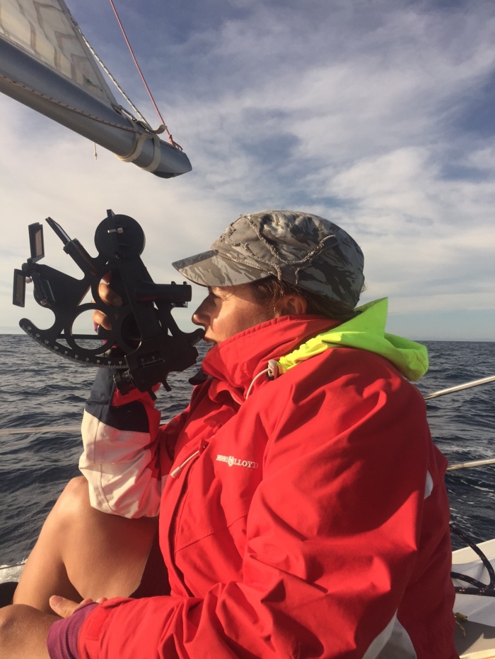
First of all you are going to need a Sextant and you can buy one on Amazon by clicking here.
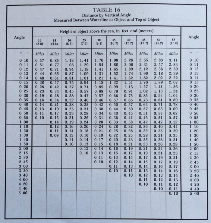
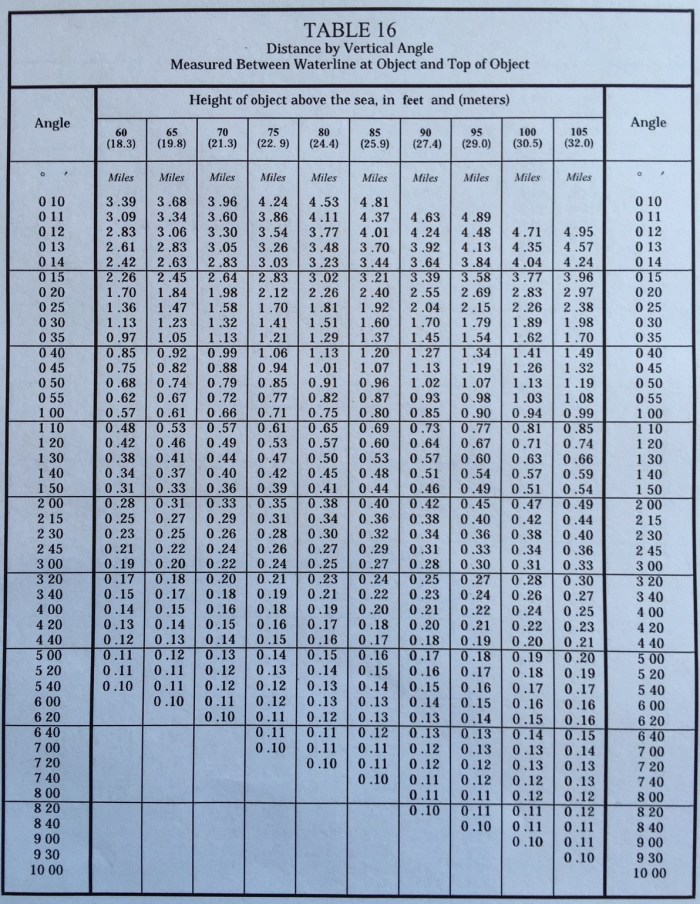
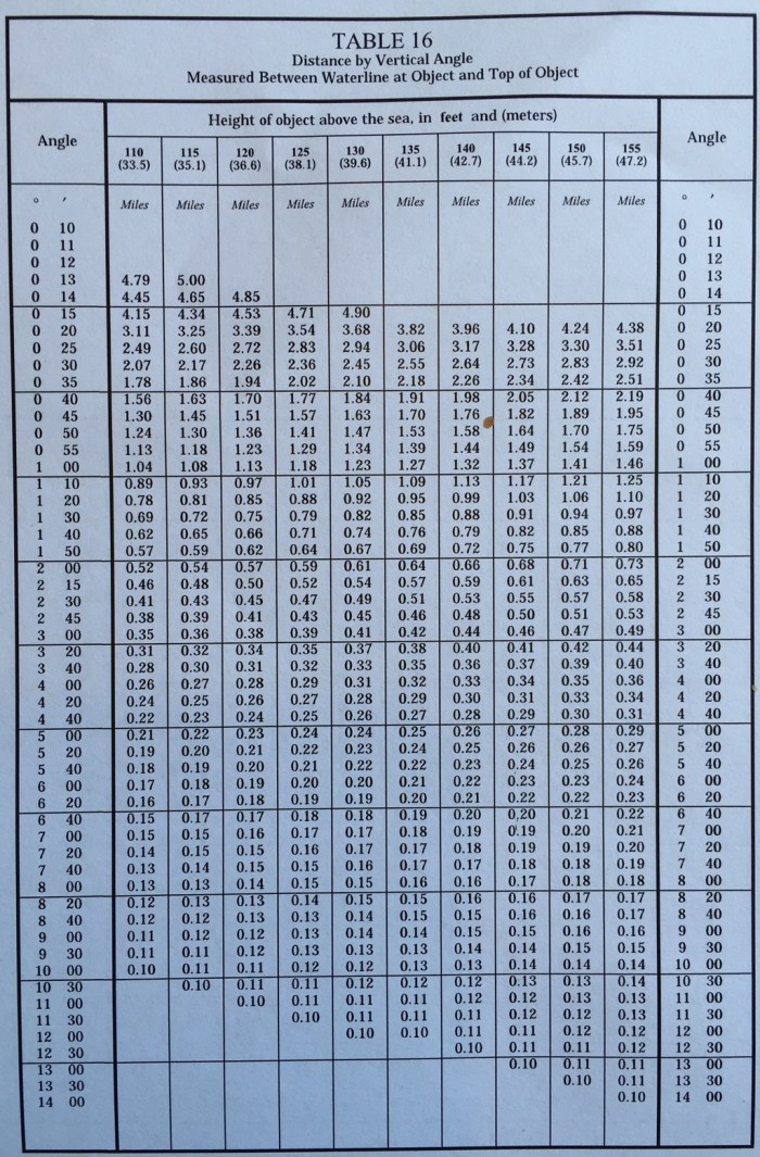
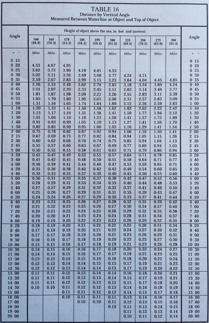
You will also need a scientific calculator. (because these make entering in things like degrees and minutes much easier) or you can use the handy tables courtesy of Mr Bowditch below.
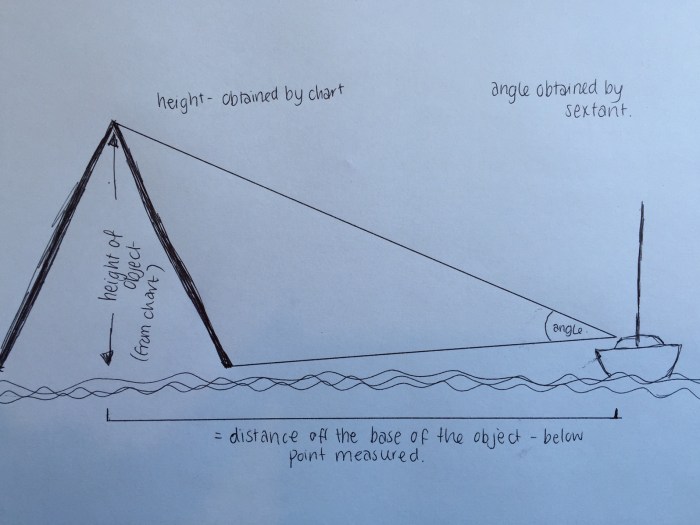
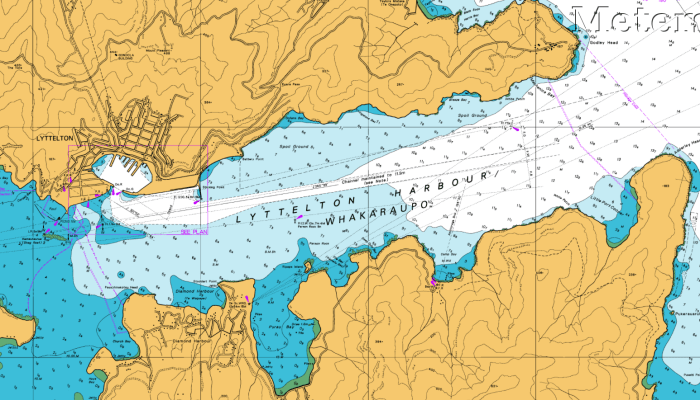
Next you need a chart and a landmark with a charted height. For this example I will use Godley Head which is at the entrance to Lyttelton Harbour (top right hand corner of the chart). You can see a number on the chart and this indicates the height. It is pretty hard to read on this picture, but lets just say it’s height is 91m (mainly because my tables don’t go any higher!)
Now you need to measure the distance between the base of an object and its summit with your sextant. You need to be able to see the whole of the object from base to summit to make this measurement – so you have to be reasonably close – ie no pesky horizon’s in the way. The object also needs to be close to the waters edge, not too far inland.
Remember that the charted height of the objects are taken at Mean High Water Springs, so you might want to take in to account the height of the tide, particularly if there is a large range and it is low tide. If you don’t make this calculation – then the calculated distance will be less than the actual distance – so you will actually be further away. Alternatively if you are close enough then you can take the measurement from the high water mark on the shoreline.
If the object is too far inland you will measure a smaller angle and you will appear to be further away than you really are.
 Note that you need to take in to account any index error on your sextant. You can read a bit more about index error here.
Also the result you get will be the distance off the base of the summit point (ie not the distance off the coastline)
OK so here is how to work it all out:
Distance from object = height of object / tan (sextant angle)
To convert minutes to decimal degrees, divide the minutes by 60. Then add to any whole degrees.
Now you know the distance in metres. Divide metres by 1853 to get Nautical Miles (nm).
Or you can use the tables below.
Here is an example to try. Godley Head is listed as being 91m on the chart, and the angle you measure with the sextant is 55′ how far off are you?
(Be aware that metres are the amounts along the top of the tables below in brackets – and the angles are on the left and right hand sides)
The keystrokes to make on the scientific calculator are:
Distance from object = height of object (91 m) / tan (angle (55’) )
To convert minutes to decimal degrees, divide the minutes by 60. Then add to any whole degrees. (On the calculator we do the division in the reverse order and then invert it, to avoid using memories.)

Angle (minutes) (60 minutes in 1 degree) Height (m) Distance (m)
Now you know the distance in metres. Divide metres by 1853 to get Nautical Miles (nm).
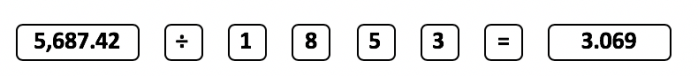
Distance (m) Conversion Factor (m to nm) Distance (nm)
(If you used 300 ft exactly converted to 91.44 m you would be closer to the answer in the tables.)
The larger the angle you measure the more accurate the calculation. For example if you measured 54’ by mistake, you would calculate you were 5,792 m away, an error of 115 m. How good are you with a sextant?
If you haven’t nodded off and are keen to learn more Coastal Navigation techniques, you can click here to learn all about raising and dipping lights and landmarks.
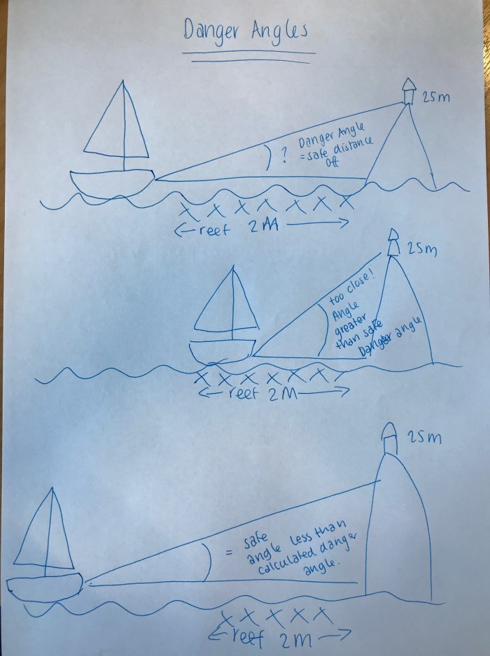
Danger Angles
This uses the same principal as mentioned above, but is a way of ensuring you don’t get too close to shore – or rocks or dangerous bits.
- Monitor the angle between the summit of the object and the base of the object
- As long as the angle you observe is less than the calculated danger angle then the boat is outside the minimum distance off.
- If the angle is the same then the boat is at the exact required minimum distance.
- If the angle is greater than the calculated danger angle then the vessel is too close.
So for example.
You want to stay at least 2 miles off a particular bit of coastline as there is a nasty reef and rocks in there.
There is a lighthouse on the chart with a height of 25 m.
What is the danger angle?
Well I reckon it is somewhere around 0º 20′ (have a look at the tables above – look along until you find the 24.4 column, then look down that column until you get to the distance you want – in our case about 2 miles or more – then look across the row until you get to the angle on the side of the page.
Here is a picture below attempting to show what I am talking about here. Unfortunately my last 25m high lighthouse was accidentally drawn a bit bigger than it should have been, but you can see that the angle gets bigger the closer you get to the object you are measuring, and the angle gets smaller when you move further away.
Note that if the height of the object is taken from the chart and it isn’t corrected for the height of the tide, the boat will be further off the object than allowed for in the calculation – a bonus added safety precaution!


Brilliant – thanks for all your hard work pulling this great article together! So much information! I remember trigonometry freaking me out – then I got on a boat and it all made sense! 🙂
LikeLiked by 1 person
yep, absolutely true. Math teachers and classes should all go sailing for a week to see the real benefit of the theory lessons… 😉
LikeLike
I am sure I’d have paid more attention had I been given a sailing related application!
LikeLiked by 1 person
Viki, I always had to sit up front because it was the only way I could totally pay attention. I had a difficult time with algebra, but loved geometry and trigonometry. Perhaps that will bode well for me as I learn more about sailing! I hope so. Great post!
LikeLiked by 1 person
Oh! You are so good – I usually leave all that stuff to my husband – he’s the mathematician and loves his sextant. I am a word person rather than a numbers person too.
LikeLiked by 1 person
Pingback: Calculating Position- by Horizontal Angle | Astrolabe Sailing
Pingback: Basic Navigation | Astrolabe Sailing
Pingback: Coastal Skipper | Astrolabe Sailing
Pingback: Navigation – Position Lines | Astrolabe Sailing
Pingback: NAVIGATION PRINCIPLE – Diary of a Seaferer